Prerequisite: Planning 2 or dean's permission
Units: 3.0
Classroom: online via Microsoft Teams
Class Time: Thursday: 9:30 AM-12:30 PM
Office Hour: Thursday: 12:30 PM -12:45 PM - Right after class time
Instructor: Zhuo Yao, Ph.D.
Instructor: Archt. Carmela C. Quizana
Thursday, December 15 2022
Instructor:Zhuo Yao Ph.D.
Instructor: Archt. Carmela C. Quizana
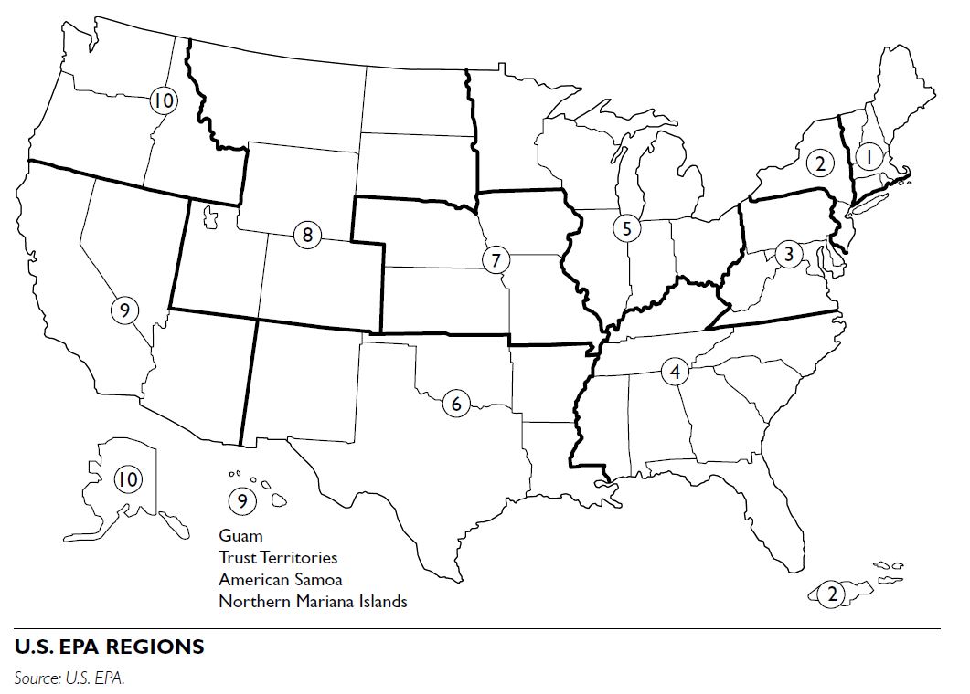
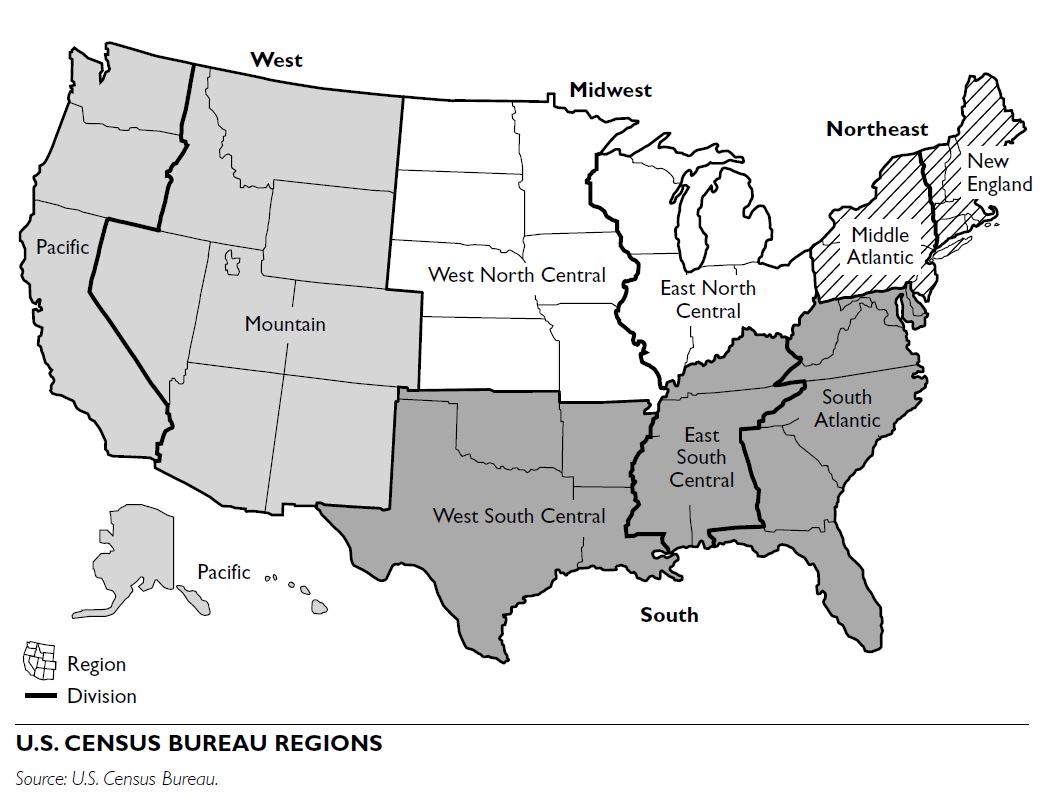
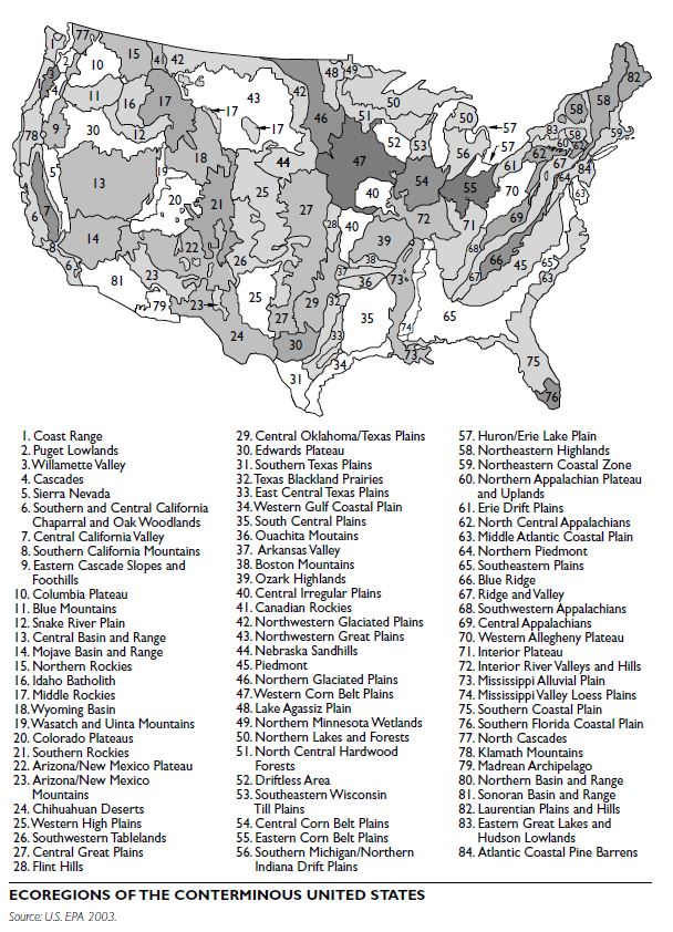
REGIONS
Regions are areas that have a characteristic or group of characteristics that distinguish them from other areas. These characteristics can be defined in terms of political, physical, biological, social, economic, cultural, or other factors. The structural and functional organization of these factors varies from place to place.
Governmental agencies and others use the term “region” to delineate multijurisdictional areas, such as those composed of more than one town, city, county, state, or nation. Environmental scientists identify regions in reference to parts of the surface of Earth, such as drainage basins, physiographic provinces, climatic zones, or faunal areas. Geographers define a region as an uninterrupted area possessing some kind of homogeneity in its core, but without clearly defined limits. It is important to understand that different types of regions exist, and that the idea of regions presents an important concept for planning and urban design.
For planning and urban design purposes, regions may be defined by political, biophysical, ecological, sociocultural, or economic boundaries. One particular type of region, the metropolitan region, often covers several of these types, because they can serve several purposes. The discussion here focuses on state-level regions and then addresses metropolitan regions.
Maps representing regional boundaries differ among various academic disciplines and government agencies. Because of these variations, the information provided here is not an exhaustive listing of all the types of regions that impact planning; rather, it is provided as a starting point for identifying various regions and regional influences that play a role in planning and urban design.
Political Regions
Political regions are civil divisions of areas. They may be defined at scales that are easily recognized, such as state, county, and township boundaries. These types of regions, known also as governmental jurisdictions, define areas that possess certain legislative and regulatory functions, important to planners and designers.
Political regions may also be groupings of areas, such as multistate regions, that are defined by political entities to serve certain regulatory, policy, and information delivery purposes from the federal level.
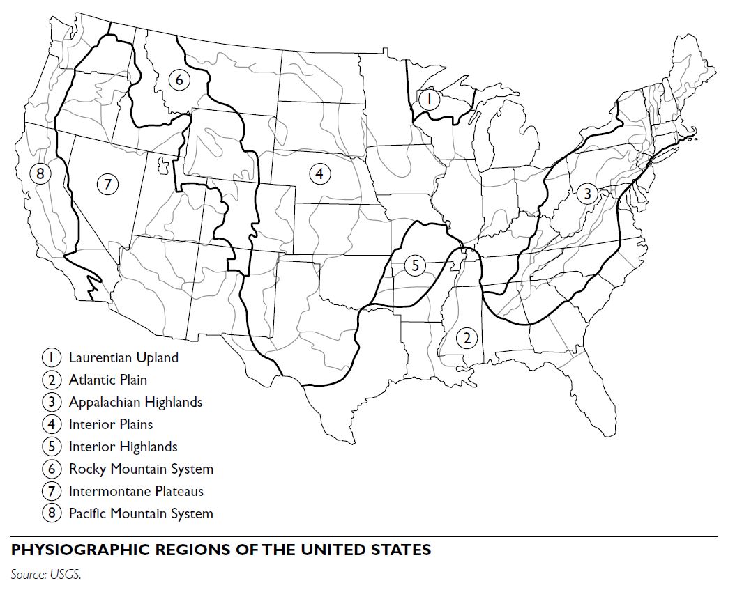
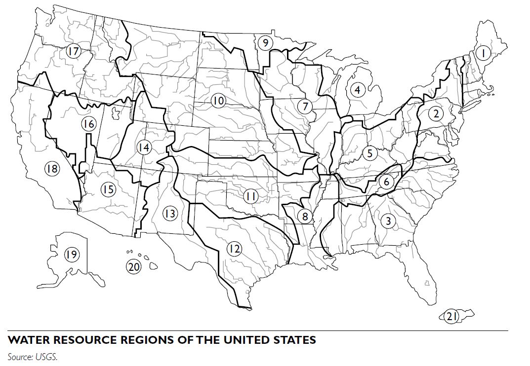
Biophysical Regions
Biophysical regions may be described as the pattern of interacting biological and physical phenomena present in a given area.
Perhaps the most commonly identified type of biophysical region used in planning is the watershed. For example, since the 1930s, the U.S. Department of Agriculture (USDA) has used watersheds for conservation and flood-control planning. Likewise, the U.S. EPA promotes watersheds for regional planning and maintains a “Surf Your Watershed” website (www.epa.gov/surf). Watersheds are important to define for numerous purposes, such as protecting drinking water supplies and identifying wetlands mitigation sites.
Purely physical and more complex ecological regions can be mapped. For example, watersheds are mapped by following drainage patterns, which are relatively easy to trace on a topographic map. Physiographic regions are based on terrain texture, rock type, and geologic structure and history.
Ecological Regions
Ecological regions are delineated through the mapping of physical information, such as elevation, slope aspect, and climate, plus the distribution of plant and animal species. The U.S. EPA defines ecoregions as areas of relative homogeneity in ecological systems and their components. Drawing on the work of Robert Bailey and others, the U.S. EPA uses climate, geology, physiography, soils, and vegetation to designate ecoregions.
Bailey (1998, 7) contends that climate plays a primary role in defining ecoregions: “Climate, as a source of energy and water, acts as the primary control for ecosystems distribution. As climate changes, so do ecosystems….” As a result, weather patterns play an important role in ecosystem mapping as well as for planning and natural resource management. For example, watersheds can be used for flood-control management as well as water-quality planning. For both purposes, charting the amount of precipitation falling in a watershed, where it falls, and how it flows assists in the understanding of flooding patterns and water pollution levels.
Sociocultural Regions
Sociocultural regions represent a type of region that is elusive to delineate and to map. They may be defined as territories of interest to people that have one or more distinctive traits that provide the basis for their identities. Sociocultural regions may span several states, such as the Midwest, the Pacific Northwest, or New England; they may also be smaller areas that may span across a political boundary. For example, the general area of northern Indiana and southern Michigan is commonly referred to as “Michiana.”
Unlike many phenomena that constitute biophysical regions, people with widely varying social characteristics can occupy a sociocultural region. In addition, human movement in response to seasons means that different populations may occupy the same space at different times of the year. For example, an Idaho rancher will move livestock out of the high country in the autumn to lower elevations with warmer temperatures. In winter, the same Idaho mountains attract skiers from settlements located at lower elevations.
ECONOMIC REGIONS
Functionally, economic regions overlap sociocultural regions. Economic processes often dominate our view of social processes in regions. For example, daily trips to work, newspaper circulation areas, housing markets, and sports teams may define economic regions. Regions may be branded based on their economic health, such as the Rust Belt in industrial decline in the northeastern United States, and the robust Sun Belt in the South and the West.
Agricultural regions are another common delineation of this type; they are often a synthesis of all regional types. The basic resources of agriculture encompass the biophysical factors of soil, water, and plants; and the sociocultural factor of people, with climate providing a linkage, a measure of coincidence for the production of food and fiber. Frequently, labels from agriculture substitute as synonyms for more incorporative regional types: for example, Cotton Belt for the southeastern United States and Corn Belt for the Midwest, or, even more specific, the Napa Valley of California and the Kentucky Bluegrass region. The U.S. Department of Agriculture has defined new farm resource regions, which break away from following state boundaries to more accurately portray the geo- graphic distribution of U.S. farm production. The intent is to help analysts and policymakers better understand economic and resource issues affecting agriculture.
METROPOLITAN REGIONS
Throughout the United States, metropolitan areas have organized political bodies that address multiple planning issues, including transportation, economic development, housing, air quality, water quality, and open-space systems. These organizations encompass more than one political jurisdiction.
Metropolitan planning organizations (MPOs) are responsible for planning, programming, and coordinating federal highway and transit investments. In addition to MPOs, other regional entities with planning responsibility include councils of government, planning commissions, and development districts.
There are more than 450 regional councils of governments in the United States. These are multijurisdictional public organizations created by local governments to respond to federal and state programs. A board of elected officials and other community leaders typically governs regional councils. Further information on regional entities is available through the National Association of Regional Councils and the Association of Metropolitan Planning Organizations.
For example, the Portland, Oregon, Metro guides regional growth through the coordination of land-use and transportation plans. As an elected regional government entity, Metro provides such a platform for the Portland metropolitan region of 3 counties, 24 cities, and 1.3 million people. Metro’s capability to guide growth derives from Oregon’s planning law that requires comprehensive plans with housing and land-use goals as well as urban growth boundaries. Another example is the Metropolitan Council of the Twin Cities, which has coordinated control over transit and transportation, sewers, transit, land use, airports, and housing policy (Orfield, 1997). A regional planning council since the 1970s, Metro Council was strengthened through the Metropolitan Reorganization Act to address regional concerns regarding affordable housing, land-use planning, and economic disparity, among other issues.
CHALLENGES TO DEFINING REGIONS
A region forges a complex entity that involves many phenomena and processes. Information about these phenomena and processes must be ordered. This involves establishing cores and boundaries, hierarchical classifications, and interrelationships. On a map, regional boundary lines—be they water- sheds, jurisdictions, or newspaper circulation areas—can be carefully rendered. Such boundaries can tend to appear more real than the zones they symbolize and divert attention from actual connections and separations. Boundaries are most often determined for planning purposes through the political process. Goals can be established for planning in a variety of ways, and these goals result in irregular boundaries, a well-recognized problem of regional (and other levels of) planning. A significant difficulty in preparing, and especially in effecting, regional plans is that most “real” units rarely coincide with governmental jurisdictions. The boundaries of metropolitan areas enclose other municipalities and overlap with additional authorities. Watersheds seldom occur entirely within a single state or province, and many of them cross international borders. Although challenging jurisdictionally, watersheds are often advocated as an ideal unit for regional planning.
Neighborhoods have long been a focus within the planning field, and neighborhood-based planning is an area that continues to grow. Among other purposes, such an approach is increasingly seen as an essential part of a comprehensive planning process to inform citywide policy and to gain input, clarify priorities, and garner support for the neighborhood- level details of such plans (Martz 1995; Rohe and Gates 1985). Defining neighborhood for programmatic ends in any given case is problematic, however, because selecting and defining target neighborhoods is a highly political and negotiable process.
DEFINING NEIGHBORHOODS
There is no universal way of defining the neighborhood as a unit. When engaging in neighborhood collaborative planning, the process of neighborhood identification and definition should be considered as a heuristic process, guided by programmatic aims, a theoretical understanding of “neighborhood,” and descriptive information on the ecological, demo- graphic, social, institutional, economic, cultural, and political context in which the area exists.
There are three dimensions to this heuristic:
- Program goals and strategies
- Neighborhood characteristics
- Contextual influences
Their consideration should be an iterative process, each stage of which is informed by the preceding stage(s), and in the aggregate providing the basis for an informed choice of neighborhood boundaries and an operational definition of neighborhood for given programmatic ends.
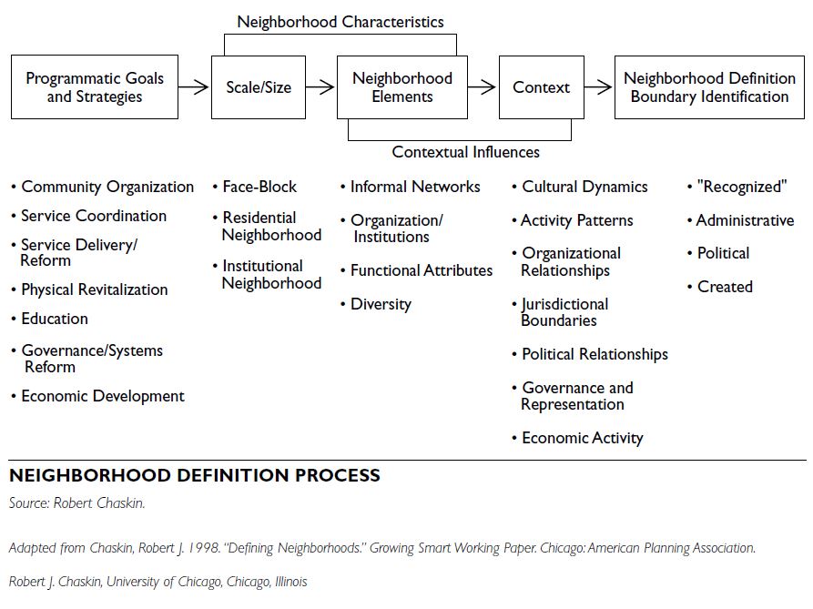
Framing the consideration of these dimensions is a set of general propositions that inform the process of neighborhood definition in any programmatic context:
A range of criteria is available that might be used to define particular neighborhoods for given programmatic ends. The process of neighborhood definition proposed here involves attention to these criteria through an iterative series of deliberations, beginning with an articulation and clarification of programmatic goals. These goals reflect assumptions about what needs changing. Program strategies reflect hypotheses about how such change might be brought about.
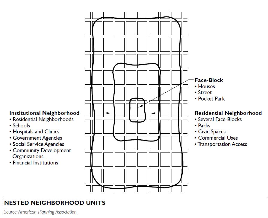
NEIGHBORHOOD SIZE
Consideration of neighborhood size should be related to the strategic intervention, operational focus, and desired impact of a given initiative. Three types of possible neighborhood constructions most useful for guiding neighborhood definition are the face- block, the residential neighborhood, and the institutional neighborhood. These units are nested constructions, each of which provides certain possibilities and constraints for fostering certain kinds of change.
Face-Block
The neighborhood as a face-block is defined as the two sides of one street between intersecting streets. As a planning unit, the face-block focuses on the interpersonal and provides a high level of opportunity for individual participation. Block-level planning will necessarily focus on a small-scale change, because individual blocks command limited resources and are too small in themselves to wield much influence in the broader community.
Residential Neighborhood
This construction focuses on neighborhoods as places to live. As a planning unit, the residential neighborhood provides an opportunity to engage residents in planning through different kinds of local governance mechanisms that can incorporate direct participation and potentially operate as a link to the larger local community. Planning at this level is likely to focus on local issues pertaining to quality of life, including housing, parks, commercial amenities, and transportation access. By itself, the residential neighborhood is less likely to be an appropriate unit of planning targeting broader systems change, seeking to foster institutional collaboration, or attempting to support economic development.
Institutional Neighborhood
The institutional neighborhood is a larger unit that has some official status as a subarea of the city. The institutional neighborhood provides the opportunity to focus on organizational and institutional collaboration and may require the construction of formal mechanisms for citizen participation if individual residents are to be directly represented.
NEIGHBORHOOD ELEMENTS AND CHARACTERISTICS
The consideration of scale of operation has implications for whether particular kinds of neighborhood elements are to be incorporated within the boundaries of a target neighborhood. It is clear that some such characteristics may be more important for the accomplishment of some programmatic goals than others.
Informal Networks of Association
While the existence of or potential for informal net- works is clearly central to initiatives seeking to develop or strengthen the social organization of a neighborhood, they are also of implied importance in any neighborhood-based endeavor. The informal social organization of a neighborhood, including neighbor relations, activity patterns, and informal service provision, differs across neighborhoods and for different populations (Lee, Campbell, and Miller 1991; Wellman and Wortley 1990) and may provide mechanisms for agency and social support overlooked in more formal approaches to neighborhood.
Formal Organizations
The availability of neighborhood organizational resources and their use also differs across contexts (Furstenberg 1993). The inclusion of formal organizations is especially important when initiative goals focus on systems change, service provision, or economic development. Because one assumption behind neighborhood-based work is that it provides the opportunity for greater access by and accountability to residents, neighborhood definition should take into account relationships among organizations and between organizations and residents.
Functional Attributes
Functional attributes include those elements necessary for day-to-day living, such as the existence of commercial activities, employment opportunities, recreational facilities, educational opportunities, and health and social services (Warren 1978). The existence of each of these elements represents a portion of the neighborhood’s capacity to sustain certain kinds of activities and promote certain kinds of change (Chaskin et al. 2001).
Population Diversity
The relative importance of population diversity or homogeneity depends greatly on an initiative’s particular goals. From an organizing perspective, homogeneity is likely to be beneficial, because it provides a clear basis for identity construction and mobilization of residents—particularly in smaller, residential neighborhoods. In larger neighborhoods and where fostering links to the larger community is desired, diversity may be valuable. This is in part a political issue, offering an opportunity to build coalitions across a broader range of constituencies. It may also be an ideological issue, in which promoting diversity is seen as a virtue in its own right.
NEIGHBORHOOD CONTEXT
Neighborhoods exist in specific contexts, and grounded information about these contexts is essential to any planning process. In addition to socioeconomic and demographic data, other tools such as community assessments, community inventories, and techniques for mapping neighborhood assets can provide valuable information on organizations, available facilities, and resident skills and priorities (Kretzman and McKnight 1993; Bruner et al. 1993). While much information is available through the U.S. Census and various administrative sources, a great deal of (often qualitative) data may not be readily available. The relational dynamics among these elements within the neighborhood, for example, and with actors beyond the neighborhood may be important for both the definition of neighborhood in given programmatic cases and for ongoing planning and implementation. Identifying and determining the most useful boundaries of particular target neighbor- hoods for programmatic purposes is much enhanced by the ability to map such relationships, and the ability to inform an interpretation of the impact of such relationships through a qualitative understanding of their dynamics.
BOUNDARY IDENTIFICATION
The criteria for boundary selection should reflect the goals and strategies of a given initiative, consider con- textual influences, and examine the sets of choices made regarding appropriate neighborhood scale and the relative importance of various neighborhood elements. The typology of possible neighborhood definitions implies certain guidelines regarding boundary identification: the face-block is bounded by the first streets that separate a resident’s home from the aggregation of homes beyond; the residential neighborhood implies some consensus regarding boundaries on the part of residents; and the boundaries of an institutional neighborhood have been in some way made official, codified and recognized by certain organizations and institutions.
“Recognized” Boundaries
Consistent with the assumptions behind the residential neighborhood, “recognized” boundaries imply the existence of some degree of neighborhood identity and provide the basis for fostering a sense of community. To the extent that the larger local community also recognizes such neighborhood definition, it may help residents and neighborhood groups to advocate their causes with government and other extra-local entities.
Administrative and Political Boundaries Administrative or political boundaries tend to define larger areas. Given a more systems-oriented or institutionally based approach, the use of such boundaries to define the target neighborhood may be appropriate. However, rarely do administrative and political boundaries coincide with each other, nor do they reflect the social organizational aspects of neighborhoods. The choice of a set of administrative boundaries to define neighborhood may be most useful for sector-bound, institutionally based interventions.
Created Boundaries
Institutional neighborhoods may be officially defined without functioning as an administrative unit. However, because such neighborhoods have no single administrative structure and are rarely recognized as political units, issues of management and long- term representation should be examined. The creation of a neighborhood governance structure that can coordinate constituent neighborhood priorities and activities, as well as represent the neighborhood to the larger community, may help to increase the long-term impact and sustainability of neighborhood- based work.
CONCLUSION
While these guidelines can help direct a process of neighborhood definition, they do not constitute a definitive blueprint for action. The act of defining a neighborhood is a product of both the social and spatial context of the area and subject to several factors, including the purpose for defining the neighborhood, the function that the neighborhood is expected to perform, and the presence of existing neighborhood organizations. Further, the delineation of boundaries is a negotiated process; it is a product of individual cognition, collective perceptions, and organized attempts to codify boundaries to serve political or instrumental aims. The attempt to define neighbor- hood boundaries for any given program or initiative is thus often a highly political process. These and other factors have to be considered during the plan-
Neighborhood centers are the areas of more intensive urban uses within a neighborhood. They provide the most localized availability of goods and services needed daily by area residents. A center provides the social and operational focus of a neighborhood. Residential uses and neighborhood-oriented, mixed- use development are inherent to neighborhood centers. Centers can be retained, preserved, revived, or created. They can be planned in new communities, converted from suburban malls, or restored from distressed inner-city neighborhood business districts. Neighborhood centers play an important role in restoring neighborhoods as the building blocks of community.
COMMUNITY GOALS AND PLANNING CONSIDERATIONS
When planning for a neighborhood center, the community may identify several goals for the center:
These goals are then translated into planning considerations:
WALKABILITY AND NEIGHBORHOOD CENTERS
The viability of a neighborhood center depends on the degree of dependency that can be established between the uses in the center and the neighborhood population. This is a function of the number of people that are within a walkable distance of the center. This walkable population must be of sufficient size to provide a consistent source of demand for the center’s retail goods and services. Local market conditions, such as per capita disposable income and regional competition, will generate different popula- tion thresholds for this demand. However, the average population density that is within the walkable distance to the center must be several times the density of the neighborhood outside the center, called the “background” density. In traditional low- density neighborhoods, the background density is typically around 15 people per net acre (6 du/acre X 2.5 pp/du). For the center, an average density of 45 people per net acre (30 du/acre X 1.5 pp/du) should be the target, with a somewhat lower density near the edges and higher in the middle of the center.
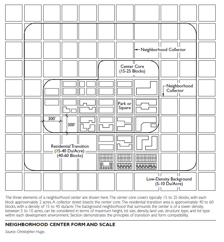
PLANNING GUIDELINES
The following are planning guidelines that can serve as a basis upon which to start identifying potential sites for a neighborhood center. The criteria included below assume typical urban residential densities of 5 to 10 dwelling units/acre. Criteria should be modified to suit the particular conditions of a community.
Even at a relatively low net density of 6 units per acre, a typical 1-square-mile detached, single-family neighborhood has a resident population of around 7,000 people. A neighborhood center that accommodates 2,000 to 3,000 additional residents increases neighborhood demand for goods and services by approximately 25 to over 40 percent. The added convenience of proximity increases the rate of patronage of the center’s residents, raising the market capture of center businesses even more.
PROGRAM GUIDELINES
The program that directs the composition of a neighborhood center can be defined according to either conventional zoning or form-based zoning. Conventional zoning will define a finite list of accept- able and prohibited uses, and often has to rely on imperfect information about current needs and future markets. Form-based zoning focuses more on providing a defined set of compatibility and operational standards, and assumes that anything that “fits” the neighborhood setting is appropriate. While more flexible, this approach has to rely on potentially imperfect assessment of the impacts that proposed uses may have. In either case, a development frame- work should set some minimum expectations for center composition.
When looking at the overall composition of a neighborhood center, the following ratios can generally be applied to the division of land uses, expressed in gross aggregate site area:
- Between 40 and (preferably) 60 percent in higher- density residential use
- Between 20 and 30 percent in mixed-use retail and service uses, with residential above
- The remaining 10 to 40 percent (depending upon the composition of residential and commercial chosen) in public uses, such as a park, library, school or other public gathering spaces
A range of housing types in a variety of densities is essential to create transitions in use intensity and to respond to changes in markets and lifestyles. Neighborhood Center Features The specific amount and mix of commercial uses in the center depend upon local conditions and are determined by a subarea or neighborhood planning process involving community stakeholders. A sample list of commercial uses includes the following:
Other features that should be included in every neighborhood center include sheltered transit stops along a primary street; defined pedestrian routes connecting the greater neighborhood to the center; a focal point, such as a square or public facility, for example, a library; and imageability, which considers architectural compatibility, preserved history, consistent signing, controlled lighting, distinct street furniture, and other elements that add to the neighborhood’s identity as a distinct place.
FORM GUIDELINES
Neighborhood centers proposed for already-established neighborhoods need to be compatible with the current residents’ perception of “fit” and attractiveness. Form guidelines should be developed to create a center that is well integrated into the existing neighborhood fabric, respects existing residences, and advances the community’s planning considerations. The following are examples of such guidelines; again, the specific guidelines to be used should be developed based upon local conditions and community desires.
Blocks, Street Pattern, and Arterials
- Maintain a 300-foot maximum block length for circulation and increased business frontages. Longer blocks may be used for traffic control if fronting higher-volume arterials.
- Create or maintain a grid street pattern for circulation, ease of orientation, pedestrian safety, and street connectivity to all portions of the neighbor- hood.
- Reduce street curb-to-curb width to operational minimums. For example, a 2-lane street with parking on both sides can be designed to have a 32- to 36-foot maximum width.
- Avoid one-way arterials.
- Orient the core of the center on the intersection of neighborhood collector arterials; avoid spanning minor or principal arterials.
Center Core
Operational Guidelines
HISTORIC DISTRICTS
Historic districts are groupings of buildings and structures, noteworthy for their age, architectural integrity, or aesthetic unity. Downtowns, residential neighbor- hoods, and rural areas that have retained their historic character often receive official historic district designation. Historic district designation is an important tool for preservation-based revitalization, including downtown and neighborhood revival, with federal and state historic preservation tax credits often used to rehabilitate income-producing properties in these districts. There are two distinct types of historic districts: those that meet standards of the National Register of Historic Places, and local districts established by municipal ordinance, which are administered by a local review board. Although these two types of districts often possess identical geographic boundaries, there are significant differences in the nature of protection and financial incentives each can offer to a community.
NATIONAL REGISTER HISTORIC DISTRICTS
Established by the National Historic Preservation Act of 1966, the National Register of Historic Places is the federal government’s official list of cultural resources worthy of preservation. This nationwide program coordinates and supports public and private efforts to identify, evaluate, and protect historic properties and archeological sites. Listed properties include both districts and individual sites, consisting principally of architecturally significant neighborhoods and buildings. In 2004, there were 12,500 listed National Register Historic districts containing more than 1 mil- lion contributing buildings and structures.
All National Register properties have been documented and evaluated according to uniform standards established by the National Park Service (NPS), which administers this program. However, most nominations originate at the state level under the auspices of a state historic preservation officer (SHPO). Guidance for preparing such nominations is found in a number of how-to publications directly available from the National Park Service. The establishment of a National Register district involves submitting completed nomination forms and a narrative description of the proposed district to a statewide review panel, which must endorse it prior to its receipt by the National Park Service for final approval.
National Register Evaluation Criteria
The Code of Federal Regulations (36 CFR Part 60, National Register of Historic Places) contains evaluation criteria focusing on districts, sites, and buildings that possess integrity of location, design, setting, and workmanship. While some districts are associated with significant events in American history, or are directly associated with the lives of prominent individuals, it is more often the case that National Register districts embody residential neighborhoods or down- towns unified by distinctive architecture, in which most buildings were constructed more than 50 years ago. Broadly worded evaluation criteria have resulted in a wide diversity in the type and geographical extent of National Register districts found across the United States.
Districts, sites, buildings, and structures may meet criteria for inclusion in the National Register of Historic Places if they:
- are associated with events that have made a significant contribution to the broad patterns of our nation’s history;
- are associated with the lives of persons significant in our nation’s past;
- embody the distinctive characteristics of a type, period, or method of construction, or that represent the work of a master, or that possess high artistic values, or that represent a significant and distinguishable entity whose components may lack individual distinction; or
- have yielded, or may be likely to yield, information important in prehistory or history.
Planning and Urban Design Implications
The National Register’s utility as a planning tool is derived from the National Historic Preservation Act, which requires federal agencies to consider the effects of their undertakings on historic properties, commonly known as a Section 106 Review. An undertaking is defined as “a project, activity, or program funded in whole or in part under the direct or indirect jurisdiction of a federal agency, including those carried out by or on behalf of a federal agency; those carried out with federal financial assistance; those requiring a federal permit, license, or approval; and those subject to state or local regulation administered pursuant to a delegation or approval by a federal agency.” At the local government level, the receipt of community development block grant (CDBG) funds or federal dollars to install a water main or replace a municipally owned bridge would trigger a Section 106 review.
Owners of private structures listed only in the National Register (and not otherwise part of a local historic district) are free to maintain or dispose of their property as they deem appropriate, provided that their actions require no federal license, permit, or funding—there is no obligation to restore or even maintain a federally listed historic property. But
because mapped boundaries of a National Register district are often identical to those of a local historic district, governing rules for the latter can provide a greater degree of protection than that offered under federal law. At times, property owner opposition can foil the establishment of a local historic district and the creation of its associated review board, as even the most ardent preservation advocates cannot deny that this will add an additional layer to a development over- sight process that may also require approvals from a planning board or zoning board. However, the guidance and rules these other boards must follow seldom focus on architectural or aesthetic features of a structure, or consider the extent to which its alteration or demolition would impact a neighborhood’s historic character. In the absence of a local historic district architectural review process, the composition of established neighborhoods and business districts risks erosion, and visual character of a community may be irreparably altered.
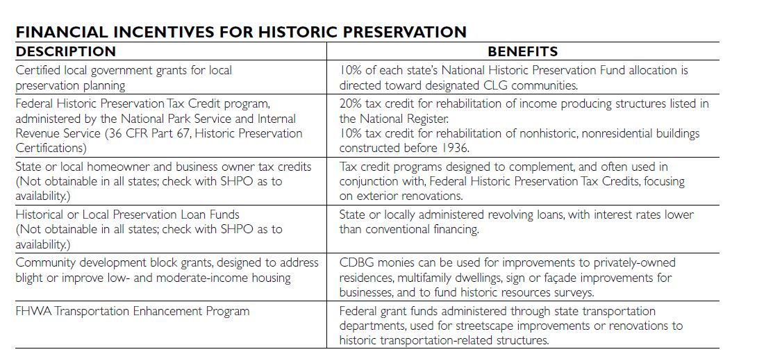
Financial Incentives for Historic Preservation
Jointly managed by the National Park Service and the Internal Revenue Service, in partnership with State Historic Preservation Offices, the federal historic preservation tax incentives program rewards private sector rehabilitation of historic buildings. The certification process for this program is outlined in the Code of Federal Regulations at 36 CFR Part 67. Properties individually listed in the National Register or those located in a National Register district and certified by a SHPO as being of historic significance are eligible.
Since 1976, these federal tax credits have stimulated more than $18 billion in private investment, and have contributed to the rehabilitation of more than 27,000 historic properties containing more than 30,000 units of low- and moderate-income housing. However, eligibility requirements for federal historic preservation tax credits provide that such properties must be income-producing and be rehabilitated according to architectural design standards set by the Secretary of the Interior. Properties receiving federal tax credits may be used for offices, for commercial,industrial, or agricultural enterprises, or for rental housing, but they may not serve exclusively as a private residence.
A number of additional financial incentives are available to assist communities undertaking historic surveys, or help out property owners willing to restore their buildings in a historically appropriate fashion. A key thread running through virtually all these programs is the need to adhere to the Secretary of the Interior’s Standards for Rehabilitation and the requirement that properties be individually listed on the National Register of Historic Places or located within a National Register district.
LOCAL HISTORIC DISTRICTS
Charleston, South Carolina, established America’s first local historic district in 1931. Today, it is one of the country’s largest, encompassing 3 square miles and nearly 4,200 contributing structures. Fueled partly by federal involvement in historic preservation beginning in the 1960s, every state has enacted legislation authorizing local preservation ordinances, enabling creation of historic districts and local boards or com- missions charged with the review and approval of development activities taking place within these districts. Common to virtually all local historic districts are administrative rules intended to preserve a structure’s exterior appearance and setting relative to the historical architecture and settlement pattern characteristics of the neighborhood. These rules are typically expressed in a historic preservation ordinance and administered by a locally created review board.
Certified Local Government (CLG) programs allow municipalities to participate more directly in state and federal historic preservation programs. To become a CLG, a local government must enact a local preservation ordinance that meets federal standards and establishes three basic items:
Benefits of becoming a CLG include special grants, professional legal and technical assistance, training, and membership in the national historic preservation network.
HISTORIC RESOURCES SURVEYS
Conducting a historic resources survey is the first step in both federal and local historic district designation. This survey identifies and evaluates all contributing structures within a proposed historic district. Extensive documentation is required, including a field inventory to visually evaluate buildings and structures, and research in libraries, newspaper archives, and municipal records. Key elements of a completed historic resources survey are described here.
Structure Inventory Forms
Structure inventory forms describe a building’s architectural style, level of detailing and craftsmanship, and integrity or alterations to its original character.
Photographs
Photographs of a building’s exterior elevations, generally of archival print quality, are included.
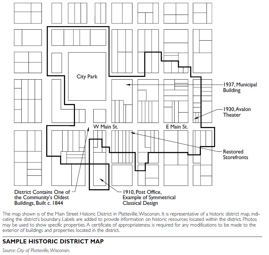
Maps
Maps depict the exterior boundary of the historic district and locations of all contributing structures, cross-referenced to each structure inventory form. The map should be capable of yielding a written description of the historic district boundary. Fire insurance maps from the nineteenth and early twentieth centuries can help establish relative dates of neighborhood development.
Narrative Report
The narrative report describes the methods used to determine the boundary and conduct the survey, the district’s historical development, the relationship of contributing structures to one another, and buildings that are noteworthy for important personages or architectural significance. This report should also list primary and secondary written materials encountered during the research. It is appropriate to identify potential threats to a neighborhood, such as deteriorating buildings neglected by their owners, architecturally intrusive noncontributing structures, and income-producing properties that may be eligible for federal tax incentives for rehabilitation.
Request for Qualifications
These survey elements can be embodied into a Request for Qualifications, used to solicit proposals from historians, architects, or architectural historians whose education and training meet the Secretary of the Interior’s Minimum Professional Qualifications Standards (36 CFR Part 61, Appendix A). A SHPO should be able to provide a prequalified list of acceptable consultants meeting these standards, which are requisite for preparing nominations to the National Register of Historic Places.
LOCAL HISTORIC PRESERVATION ORDINANCE
An ordinance is necessary to identify procedures for creating local historic districts and administering the review of building renovations or alterations to properties located within the district. It should reference the legislative intent of the state enabling act, which grants municipal authority to establish historic districts. The ordinance should require a survey to identify and evaluate all contributing structures, and the preparation of a map depicting district boundaries. It typically establishes a historic district commission or architectural review board that is charged with the review of development proposals within historic districts.
Some states require a vote of approval by a majority, or even two-thirds, of the residents of a proposed local historic district. In other states, a city or town council is empowered to establish a local historic district after conducting a public hearing.
Historic District Commission/Architectural Review Board
A local historic district commission, which may be known as a heritage preservation commission or an architectural review board, depending on the nature of the ordinance, administers a process sometimes referred to as “historic district zoning.” These boards are distinct and separate from planning or zoning commissions. They have their own rules of procedure and issue their own approvals, known as certificates of appropriateness, when approving construction plans. The historic district commission’s actions do restrict what a person can do with their property; however, there is a significant body of case law that supports the right of a community to regulate a building’s visual and historic character.
The review board’s jurisdiction typically includes exterior renovations, building demolition, and new construction. The board may also be responsible for approving façade improvements and signage in order to protect and enhance the visual character and encourage economic development in commercial neighborhoods. Some communities allow “minor work” such as repair or replacement of exterior materials with identical or similar materials to be reviewed by staff, with an appeal to the full board if necessary. When creating a historic district commission, the local governing body should appoint members who have a background in history or architecture. These qualifications are necessary to meet National Park Service criteria for a certified local government (CLG).
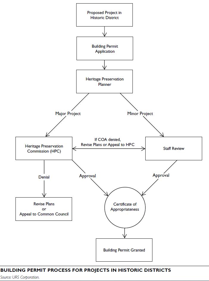
Certificate of Appropriateness
The architectural review process begins when a property owner applies for a building permit for repairs or alternations to structures located within a local historic district. The historic district commission or architectural review board grants a certificate of appropriateness prior to the issuance of the building permit or certificate of occupancy. Each commission develops its own written procedures and standards guiding modifications to historic buildings, but the most commonly used measure is known as the Secretary of the Interior’s Standards for Rehabilitation (36 CFR Part 67, Historic Preservation Certifications), which is also used to administer the federal historic preservation tax credit program.
Appeals
Local preservation ordinances should also contain a provision for property owners to appeal the decision of a historic district commission, with such appeal directed toward an existing entity such as a zoning board of review. When considering appeals, the zon- ing board of review should not substitute its own judgment for that of the historic district commission, but rather consider the issue upon the findings and record of that commission
CHALLENGES TO HISTORIC DISTRICT DESIGNATION
Planners should be aware of arguments used by opponents to historic district designation, who may raise concerns about added construction costs or excessive regulation.
One ongoing debate is that historic district commissions “fossilize” neighborhoods by imposing very narrow or personal definitions of appropriateness that discourage architectural creativity and diversity. Others argue that compliance with architectural design codes restrict the ability of businesses—particularly national franchises—to adjust to market conditions, or are beyond a homeowner’s financial capacity to carry out needed exterior renovations. Indeed, blight becomes an issue when property owners fear or resent an additional layer of bureaucracy, or cannot afford historically appropriate building improvements.
To prevent individual board members from becoming arbiters of “good taste,” historic district commissions from the outset must have clearly written specifications to determine what constitutes appropriate construction or renovation, and what will add or detract from a historic streetscape. This is why local boards are encouraged to rely on the nationally accepted Secretary of the Interior’s Standards for Rehabilitation, possibly supplementing these with more detailed guidelines that are specific to a particular district. Proper documentation will elevate the review process above personal preference or bias, and thus provide a consistency of decision making.
It is recommended that historic district commissions prepare an informational pamphlet that addresses the concerns of property owners, builders, and architects. Pamphlets should summarize the historic preservation ordinance’s guiding principles and procedures, list which actions are exempt from design review, and provide graphic illustrations of the types of improvements that would be granted a certificate of appropriateness.
A final challenge is “demolition by neglect,” which is defined as the destruction of a building through abandonment or lack of maintenance. This problem is attributable to impoverished owners, difficulties arising from unsettled estates, or uncaring absentee landlords. It is important, therefore, that property owners be made aware of financial incentives that can assist in rehabilitation.
Current interest in the water’s edge and the flourishing of public spaces on waterfronts across the United States is the result of a process going back for decades. Once places of trade, military, or industrial advantage, or even places of neglect, waterfronts are increasingly seen as economic and social assets to their communities.
STANDARDS AND REGULATIONS
When contemplating new waterfront projects, take into account the specific standards enforced by federal and state regulatory systems. The following agencies have a role in the regulation of our coastal ecosystems.
Federal Agencies (for Navigable Waterways and Connected Wetlands) - U.S. Environmental Protection Agency (EPA) - U.S. Army Corps of Engineers - National Oceanic and Atmosphere Administration (NOAA) - The Department of Homeland Security (especially the Federal Emergency Management Agency (FEMA) and the U.S. Coast Guard) - U.S. Fish and Wildlife Service
State and Local Authorities
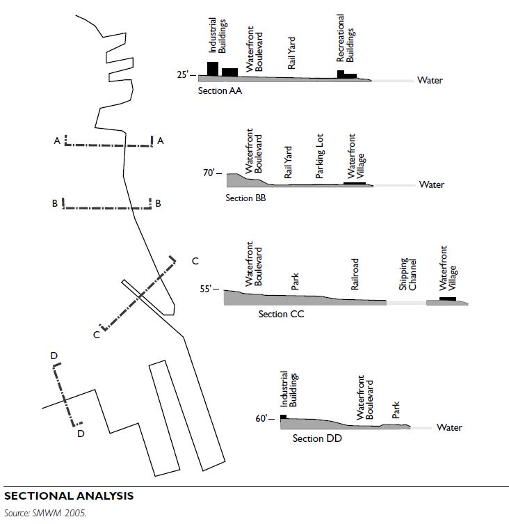
MORPHOLOGICAL ANALYSIS
To understand a waterfront, study its evolution. Consider the shoreline’s various stages of development. Create a series of diagrams analyzing the historic and current conditions of the water edge, which will be critical in designing its future uses. In addition, understanding the sectional analysis of a coastline is important when planning a new use on the water and its connections to the built fabric of the city.
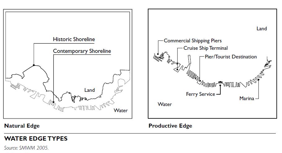
Natural Edge
A natural edge diagram describes the undisturbed conditions of the shoreline’s ecosystem and its often rich variety of species. Such natural conditions might be used as a benchmark for waterfront restoration.
Productive Edge
A diagram of the waterfront’s historic productive uses can be helpful when planning new uses on the water. Maintaining productive waterfront uses is often a priority. Elsewhere, historic artifacts might be incorporated in a new design as cultural and perhaps functional features, such as old gantries, working piers, and cranes. Historic interpretation can be important for the new design by creating a strong identity of a place rooted in the region’s past.
ANALYSIS OF ENVIRONMENTAL AND ECOLOGICAL WATERFRONT CONDITIONS
Pollution and deterioration of the coastal environment often requires major investment in its restoration, considerably increasing a project’s total cost. Pollution mitigation, remediation, stormwater management, stream and wetland restoration, and habitat protection are some of the basic aspects of waterfront restoration and development.
Environmental education is a key component in successful waterfront revitalization. Include design elements and signage that provide information about the historic uses of the waterfront area and its current environmental status. Consider alliances that involve local citizens and institutions in long-term restoration efforts. Inform the local community about the health hazards of activities along the new waterfront, such as fishing and swimming, if there is potential for danger.
Ecology of the Water Edge
Investigate ecological conditions at the shoreline to determine the type of cleanup and the subsequent appropriate ecological system when designing the waterfront. Often, this process can inspire the designer to incorporate ecological elements, both aquatic and terrestrial, into the new design, turning them into opportunities to educate and inform the public about the natural history of the shoreline.
Transportation and Connections Abandoned or active rail lines, freeway structures, neglected culverts, chain-link fences, walls, or even private gates can be obstructions to accessing the waterfront. Take into account their presence and potential for relocation when redesigning new water- front destinations.
Land Use
Many land uses can be found on the waterfront, depending on its economic and social function. Land uses can include industrial production, commercial development, transportation nodes, recreational uses, public infrastructure, institutional and educational structures, and new residential areas. Successful waterfront development will include several coexisting uses, providing urban vitality and activity at the water’s edge.
Environmental Factors
Given the heavy industrial uses that occurred on the shorelines in the past, cleanup processes and pro- grams play a fundamental role and are a key step in the redevelopment process of sites along the water- fronts. Soil analysis is a basic step in the challenging process of cleanup and restoration of a waterfront area. Cleanup costs can be substantial and can add to the total cost of a waterfront redevelopment project. Because of contamination in the ground, in buildings and other structures, and possibly in groundwater or adjacent surface water, state and federal environmental agencies and financial institutions often require considerable remediation or cleanup before redevelopment can occur, or as part of the redevelopment process. Of particular concern are any anticipated changes to a structure’s configuration. A brownfield, as defined by U.S. EPA, is a polluted property that in order to be redeveloped needs to undergo such cleanup process. Also, many jurisdictions prohibit additional fill or require mitigation measures to replace open water.
WATERFRONT DESIGN PROCESS
Because of the often controversial and political nature of waterfront projects, their development is a complex process involving many different state and federal authorities as well as grassroots organizations and community stakeholders.
Community Involvement
Involve the community from the beginning in water- front redevelopment projects. Educating and informing the community about the challenges ahead will create a strong foundation on which to draft a long-term vision for a new, inclusive waterfront. Environmental monitoring and education are effective tools to build a large community constituency, together with effective visioning tools such as community workshops and charrettes.
Remediation Plan
A remediation plan is necessary when high toxicity levels are found on-site. The intensity and thoroughness of the cleanup process differs with the specific uses planned for the site: a residential area, for example, requires a much higher level of remediation than an area for a parking structure.
Conceptual Framework Design
When designing a waterfront, issues of scale play a major role. A framework plan often builds on previous studies and has the overall planning of the area as a main goal. A comprehensive framework plan allows flexibility and leaves room for future land-use decisions regarding the waterfront. This type of plan ensures a cohesive allocation of investments, connects the new sites to the rest of the urban or rural developments, and supports appropriate uses on the water.

Detailed Design
A detailed plan finds its place within a strong frame- work and usually focuses on the appropriate specific program for an area. A detailed plan for a waterfront calls for new and reinterpreted uses and creates new places and destinations through the implementation of solid design guidelines.
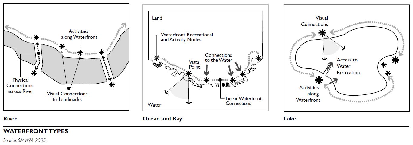
WATERFRONT TYPES
Different waterfronts encourage different types of activities. River waterfronts promote activities enhancing connections across the two riverbanks: physical and visual connections are equally important in this kind of waterfront. Waterfronts by the ocean or the bay connect the urban fabric to activity nodes along the water and promote the use of piers for recreational activities. Finally, a body of water such as a lake or a reservoir promotes activities around the edge, invites points of activity along the shore, and is a great setting for water-related sports.
WATERFRONT DESIGN COMPONENTS
Waterfront projects can have different scales, from a plaza to a greenway, and different character, from container port to wetland. Waterfront components can be a series of open-space elements, a system of connections to the inner core of the city, a new development on the water, or a strategy for sustainability.
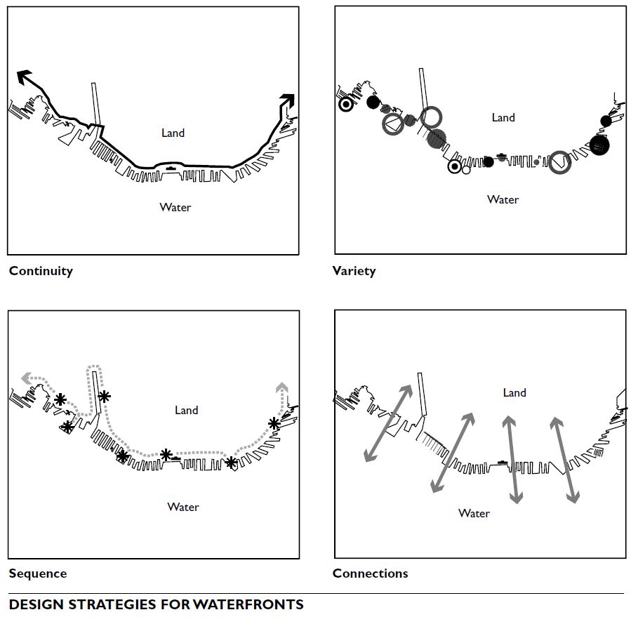
Design Strategies
Consider the following overall strategies for the design of a successful waterfront area.
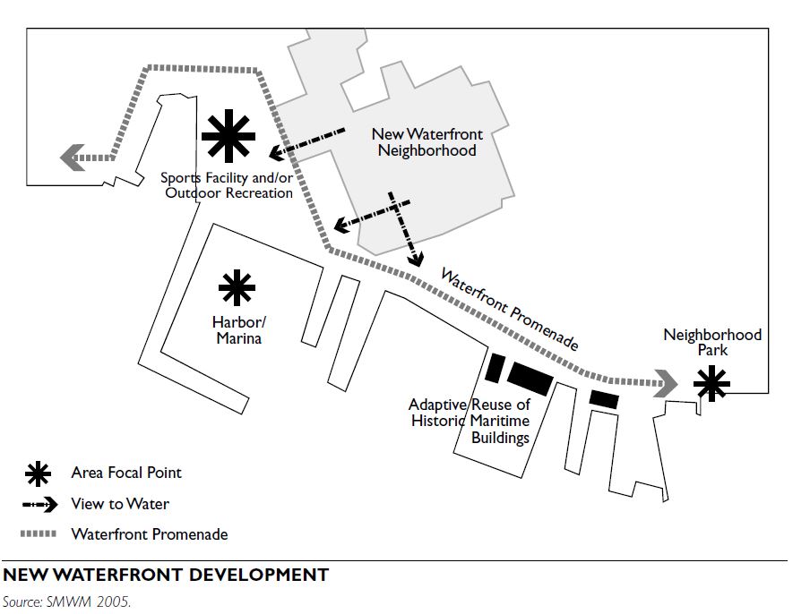
Continuity: A continuous waterfront system for walking, jogging, biking, and rollerblading.
Sequence: A sequence of recurring open spaces at significant points along the water. Such places might have a special view or might be directly aligned with major city streets.
Variety: Multiple uses along the water create successful synergies and accommodate different users.
Connection: Visually and physically connect spaces along the waterfront and from the new waterfront to the bay (with views and piers) and to the city (through access points and pedestrian circulation links).
Design Elements
Open Space
Plazas: Waterfront plazas are often part of larger waterfront developments, such as commercial and recreational buildings along the water. They are often hard-surfaced areas with seating, shaded areas, and prime views of the water. In larger developments, plazas can be designed to allow for large recreational gathering structures such as amphitheaters or stage areas where local civic events can be held. They also offer great opportunity for displaying the historic memory of the waterfront through interpretive features or art installations.
Parks: Along the water, parks can be hard- paved areas or more natural soft areas. A new park can also be connected to a local ecosystem, such as a wetland, and to larger natural areas, such as greenways along the shoreline.
Piers: Piers can be interesting components in the redesign of waterfronts. They can reinterpret history, provide views, and promote recreation such as fishing. Incorporate safety elements such as lighting and railings, as well as sitting areas with benches to rest and enjoy the view. Focal elements such as art installations or small commercial buildings can be included at the end of a pier to make walking and strolling along its length a more exciting activity.
Connections
Paths: Biking and jogging are among the more iconic uses of a recreational waterfront. Water views and linear, often unobstructed, connections along the water make these activities especially pleasant. Design paths to accommodate these activities. Use smooth paving materials in areas for bikes, and ensure that path widths accommodate bikers and walkers alike, possibly with separate rights-of-way.
Promenades: A promenade can connect spaces along the water or be a destination in itself, offering recreational opportunities for strollers, joggers, bikers, and in-line skaters. Depending on the specific character of the waterfront, promenades can be constructed and sophisticated urban places or natural and understated linear connections. Design elements such as paving materials or light fixtures can vary according to such character. Accommodate biking and jogging activities with materials that can withstand the effects of the moist microclimate.
Water connections for tourists: Tourism can be an economic engine driving the waterfront redevelopment process. Water taxis and ferries can be tourist attractions, as well as interpretive tools of an area’s productive past.
Development
Water connections as mode of transportation: When waterfronts are more developed and can support a high number of residential buildings, water connections can become an effective mode of transportation, making the link between residence and work place an easy and interesting transit alternative.
Working waterfronts: In the past, waterfronts were the exclusive realm of harbors, fishing fleets, shipbuilding, warehouses, and manufacturing plants. Changing technology made some of these uses obsolete, and rising land prices connected to the rediscovery of the water edge have endangered many local maritime enterprises. These enterprises can add to the local economy and to the city’s character. Consider retaining and promoting existing maritime uses when possible, and integrate their needs with the overall plan of the new waterfront.
For large working ports, container handling, shoreline configuration, updated equipment, regional distribution networks, and environmental impacts are key planning issues. Planning efforts at many ports seek to designate safe and inviting locations for the public to view port activities.
Infill and adaptive use: Infill development can be a catalyst for change in forgotten areas of a waterfront. Adaptive use of historic buildings can be a powerful redevelopment strategy to create new destinations and to reinterpret the waterfront’s past in new ways. Successful renovations can generate dynamic synergies that can boost local economies and provide a sense of place.
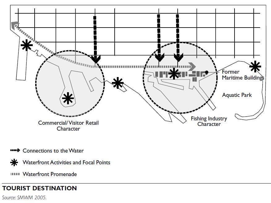
Recreation and tourist destinations: The number of tourists it attracts is often the measure of a waterfront’s success. Promote tourism in the early phases of waterfront redevelopment to encourage investment. Educational, recreational, and interpretive features and activities are often found in the public areas of a waterfront, where visitors exploring the character of the region can readily appreciate a new identity anchored in the past.
New mixed-use development: After the initial success of a waterfront redevelopment, larger developments often follow. All uses benefit from the prime location and the recreational opportunities a new waterfront offers. Some jurisdictions invite residential uses along the water, to bring density and vitality to the area. Be sensitive when locating residential uses at the edge, to ensure public access is maintained.
Art: Public areas along waterfronts offer great opportunities for education and art appreciation.
In particular, the rich social and cultural heritage of these sites encourages artists and a municipality to collaborate in often striking public art projects that foster a sense of place. Allow flexibility in waterfront plans to ensure that art interventions and programs can be incorporated.
Sustainability
Ecological preservation: Every waterfront is part of a watershed. Consider sensitive habitats and floodplains during the design process.
Ecological design: Natural conditions of water- bodies and the edge conditions are increasingly seen as opportunities to inspire design and suggest uses along the water. Many new developments incorporate ecological design principles as powerful elements of the design concept. Ideas such as wetland restoration, native vegetation preservation, and stormwater management have created a new design vocabulary in waterfront planning.
Industrial parks are areas within a community designated for activities associated with industrial development, which can include materials processing, materials assembly, product manufacturing, and storage of finished products. Uses can include manufacturing facilities, warehouse distribution centers, and truck terminals.
Industrial parks can be stand-alone developments within a community, or they can be adjacent to or part of a larger regional industrial district spanning a number of contiguous jurisdictions. Industrial parks rely on the availability of large tracts of land, efficient transportation systems, and sufficient infrastructure for their success and for their ability to integrate into the larger community.
SITING PARAMETERS
Transportation
Industrial parks should be located in close proximity to major transportation systems, including regional and interstate highway systems, with an efficient system of local roadways between the industrial park and the highway system. Access to other types of transportation systems, such as rail, port, and air- freight, should be available, if they are characteristic of the region and in demand by the industry.
Utilities and Infrastructure
Industrial parks require dependable utility systems. Sufficient supplies of water for domestic fire protection and for use in industrial processes should be available, and sanitary sewer systems need sufficient capacity to support waste generated in the park. Adequate sup- plies of natural gas and electricity also are necessary.
Consideration should be given to developing regional stormwater management facilities to support the industrial park. Best management practices for stormwater quality and quantity are ideally developed on a district or regionwide basis, based on the watershed of the area. If this approach is not possible, on-site stormwater management facilities need to be provided. Open stormwater management facilities should be allowed within perimeter buffer areas and planted areas, to preserve other land areas for industrial development.
Industrial park developers must also take into account telecommunications utility infrastructure.
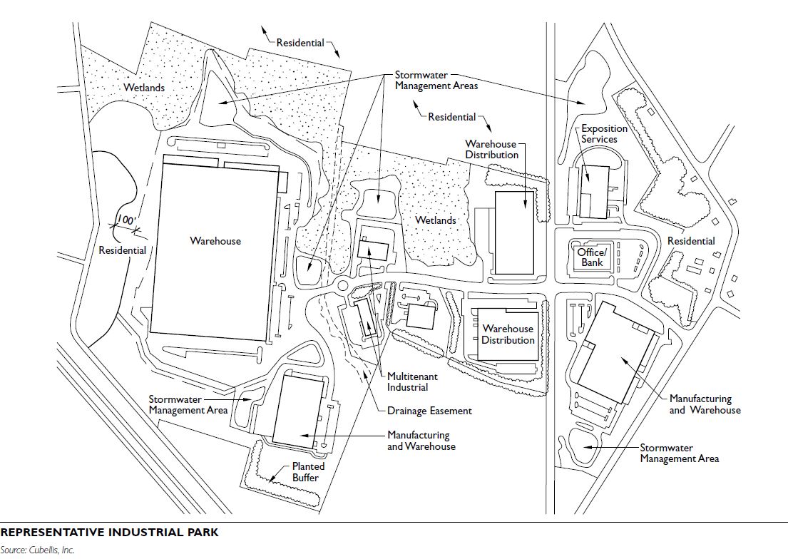
Land Area
The land area needed for an industrial park can range from 20 acres to hundreds of acres. An area between 50 and 100 acres in size allows for flexibility for parcels, planting, and internal transportation and parking systems. Large, rectangular tracts of land that are available for development at competitive prices in the region should be considered as sites. Land should have minimal impediments to development, to make it competitive in the marketplace. Conditions such as steep topography, exposed bedrock, wetlands, sensitive environmental areas, and irregularly shaped parcels can contribute to site development costs and inefficient use of the land.
Labor Force
Development of the industrial park will be directly related to the ability to attract labor from proximate areas to the park to serve the industry within the facility. The available labor force is directly related to the type of industry that can be attracted and the likely success of the park. Among the labor force considerations to assess are the following:
SITE DESIGN CONSIDERATIONS
Organizational Systems
Industrial parks tend to be organized according to a grid system, to optimize flexibility in parcel shape and size. Internal street patterns also follow a grid, to accommodate heavy truck traffic. Newer industrial parks, which often include office space and require less excessive truck use, may use more curvilinear road systems that follow the natural contours of the land. Parcel sizes often vary, to capture changing market conditions. Most parcels are between 200 and 300 feet deep and allow for land to be resubdivided to create larger lots, if desired.
Circulation and Parking
Traffic, road, and parking standards depend on the uses allowed in the industrial park. Institute of Transportation Engineers (ITE) standards should be reviewed when developing the circulation and parking system for the area. These standards include road width and bearing capacity, truck loading and turning requirements, traffic generation guidelines, and parking requirements based on type of use. Major access points should not conflict with pedestrian movement or adjacent residential areas, and local traffic flow should not be disrupted as a result of truck movement.
Buffers and Open Space
Most industrial parks require planted buffers to separate them from residential uses. They also require sites to be planted and to retain tree cover. Modern industrial parks are often lower in density than older industrial areas; some require between 70 and 80 per- cent open space. Height and bulk standards, floor area ratios, and other density standards for structures should be compatible with competing industrial areas throughout the region, yet provide for land to be set aside for buffer zones, greenbelts, and protection of environmentally sensitive areas.
Structural Elements
While utilitarian industrial parks with inexpensive structures and minimum site improvements are often required for competitive reasons, enhanced design adds value to the industrial park, the community, the owners, and the employees. Among the elements of enhanced industrial park design are underground utilities, architecturally harmonious structures, planted areas, and road systems that allow for safe and efficient movement.
POTENTIAL IMPACTS
The compatibility of industrial uses with adjacent uses will depend highly on the type of industry that locates in the area. When considering an industrial park, the following are among the types of typical impacts from industrial uses:
Performance Standards
Industrial parks are increasingly governed by performance standards. In addition to the typical setbacks, buffers, and landscape planting requirements, these standards govern light and glare, noise, vibration, air pollution, odor, heat and humidity, electric interference, radiation, outdoor storage and waste disposal, traffic, fire and explosive hazards, and toxic and hazardous materials. Consult local regulations or published materials on industrial performance stan- dards to develop specific standards.
Park Covenants
In addition to zoning regulations, covenants can also be used to guide industrial park development. Such covenants can describe the type and character of industry allowed within the industrial park, general guidelines for building construction, environmental considerations, buffer zones, and overall general aesthetics. These assure potential users that their investment will be protected by similar development within the industrial park. Covenants can also be written so that existing users within the park have input into the approval of future users locating within the park. Like zoning regulations, park covenants should be clear and result in a positive conclusion when all conditions are complied with.
EMERGING TRENDS
Mixed Uses
Industrial parks of the past were typically confined to industrial-related uses; today, related uses such as manufacturing support facilities, office and office support, and research-related uses should be allowed in them. There are even circumstances where hotels and small retail activities can be sited in the industrial park. If they are desired, these uses should be placed on the periphery of the industrial park or in places that enable traffic to easily flow without intermingling with the core activities of the industrial park. Office uses, showrooms, and other ancillary or support functions such as conference and hotel facilities may be placed in the more visible areas of the park.
Eco-Industrial Parks
Eco-industrial parks are industrial parks in which ten- ants seek to minimize or eliminate waste generation, energy use, and other environmental impacts through symbiotic arrangements with other facilities in the park. Because of the interrelationships among the ten- ants, eco-industrial parks often require a more sophisticated management and support system than traditional industrial parks. Several eco-industrial parks are in operation in the United States, including Cape Charles, Virginia, and Londonderry, New Hampshire. Because of the reduced impacts of these facilities, they may be more compatible with nonindustrial uses than conventional industrial parks.
Eco-industrial parks can be described as generally having the following characteristics:
An office park is designed specifically to serve the office space needs of a wide variety of businesses. Office parks often include both multitenant office buildings owned by an investor, such as the developer, and properties built to suit the particular needs of a company. Office parks have evolved as master- planned, mixed-use developments incorporating a variety of ancillary uses such as residential, retail, entertainment, and recreational components. Developers of office parks often consider including neighborhood-type elements, such as retail establishments, entertainment and recreational options, green spaces, and, in some instances, residential development, along with other commercial uses such as light industrial buildings and medical office buildings. The overall goal is to create a vibrant, self-contained business community that is more than just a place in which to work.
TYPES OF OFFICE PARKS
Two of the most common types of developments today are campus-style office parks and urban-style office parks.
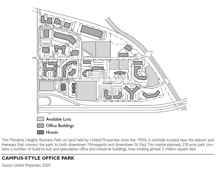
Campus Style
The campus-style park, typically a large, relatively self-contained development that could cover several hundred acres, is the more traditional type. To make the parks attractive to office space users, developers often add retail uses such as convenience stores, restaurants, and dry cleaners. Residential development, including for-sale and rental housing, is increasingly integrated into campus-style office parks. These types of office parks are more likely to be constructed in communities where there is an abundant supply of undeveloped land.
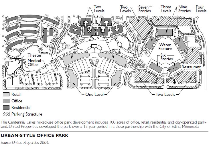
Urban Style
An urban-style office park is typically located within a more developed area of a community, where developable land is at a premium. Because of high land costs, these types of office parks are more likely to require higher-density development, including high-rise office buildings, to make them economically feasible. Increasingly, urban-style office parks are being built based on traditional neighborhood development (TND) or new urbanist principles, creating places where people can “live, work, and play” in the same setting. For-sale and rental residential housing, along with entertainment, retail, restaurants, coffee shops, hotels, and outdoor recreational amenities is among the variety of mixed-use components developers use to make urban-style office parks attractive places in which to do business.
SITE LOCATION PARAMETERS Location is the primary component of a successful office park development. Highly competitive market conditions and high land costs make it imperative to choose a site that contains all the necessary features and has a need for such development.
Site Size
Office parks are built over many acres—project sizes can range from 20 acres or more for an urban-style office park to several hundred acres for a campus-style office park. An adequate amount of space is needed to accommodate all the uses for which an office park is intended and to create a unique environment that appeals to the end users. Office parks often serve as anchors for a new town center development that encompasses a substantial quantity of land.
Access and Transportation
Convenient highway access is typically a critical factor in locating a campus-style office park. The local street system must be able to handle the increased flow of vehicle traffic that an office park will generate so that the customer can quickly get to a destination. Access to local and regional transit systems is also an increasingly important aspect of office park development. Because of the concentrated number of people in a park, office parks can provide a community with an opportunity to enhance its overall transit system, through the development or expansion of a regional transit hub adjacent to the development.
Visibility
Visibility is one of the key factors that business space users rely on when choosing a site location for their company. An office park needs to stand out both physically and visually as a readily identifiable feature of the local business landscape and a recognizable component of a community. Some of the ways to accomplish this could be a recognizable building or tenant name, monument signage, or a unique landscape or art form.
Demographics and Trends
Part of the location selection process is researching the community to determine the likelihood of attracting enough business users to make the park successful. This includes understanding the demo- graphic makeup and trends that exist in the local and regional business community. Rather than waiting for the market to respond when a new project is launched, office park developers often seek to create value and generate substantial revenues from the project in as short a period as possible, to recoup initial investments and cover ongoing land, investment, and development costs. For this reason, developers favor providing a mixed-use development, which allows the developer more quickly to absorb the land and put it into productive use.
SITE DESIGN
Specific site design issues will depend upon the number and type of tenants that will occupy the park. Local regulations also provide minimum standards required for each design issue. A planned unit development can give a developer an opportunity to create a unique environment with more design flexibility relative to standard regulations. Below are some of the commonly addressed site design issues.
Circulation
Employees, vendors, and customers must be able to travel to and from their destinations within the office park in a convenient and timely manner. The side- walk, path, and street network should be designed to facilitate efficient movement patterns.
Parking
Parking requirements will vary depending upon the number and size of buildings and the types of uses included in the office park. Facilities with access to transit, organized carpooling, and other options that may reduce vehicle trips require fewer parking spaces than those where such options are not avail- able. When creating a mixed-use office park, shared parking opportunities may be available. An example is a movie theater located next to an office building: these two facilities could share a parking area because the hours of operation of each are different and rarely conflict. Local regulations should be consulted to determine actual parking requirements.
Building Height and Massing
Office space is changing from its past configuration. The average ratio of office space per employee is shrinking from 250 feet to 150 feet per employee, and companies are increasingly locating as many employees on the same floor or on contiguous floors as possible, to minimize disruption in business operations. Floorplates for office buildings, which previously were between 22,000 to 26,000 square feet, are now much larger, up to 45,000 square feet. Therefore, there are more employees, requiring more parking needs.
Utility Systems
Office parks require utility systems that support all of the necessary operations within the buildings, and adhere to building and fire codes. Utility factors deemed critical by business space users today include underground utility connections, redundant electrical power sources, state-of-the-art fiber-optic connections, and access to satellite-based communications.
Urban office parks often have double and triple power redundancy and access to multiple data “pipe” supplies. Campus-style office parks are more likely to rely on a generator for power backup.
Electricity
Electrical requirements should be determined based on the use of the building. However, most large facilities now require that standby generators be provided on-site to supplement public supplies, should an out- age occur.
Natural Gas
A source of natural gas is generally required for heat- ing and air conditioning, as is a source of emergency power to operate the building during power outages or as a backup source of power to computer systems.
Sanitary Sewer
Office parks require either the service of municipal sewer systems, in order to serve the buildings, or sufficient land area for the on-site disposal of wastewater. Local and state codes should be referenced prior to siting an office park to determine the feasibility of on- site wastewater treatment and disposal, based on the quantity of wastewater generated.
Water Supply
Office parks will need access to a water supply, typically provided by a municipal water authority.
Stormwater Management
Runoff from paved areas, especially parking lots, has the potential to create stormwater management issues. Sufficient land area must be available to provide on-site stormwater collection, and management facilities must meet Clean Water Act best management practices and local regulations.
Aesthetics
Among the elements used to address the aesthetic elements of office parks are standards for building
materials and uses, overall architectural design, vegetation, signage, and lighting. These elements help provide a specific identity for the office park, which is important to the developer’s marketing efforts and to park tenants. Most business parks have protective covenants for this purpose.
Open Space
Office parks often include significant amounts of open space. In addition to publicly accessible vegetated areas, common open-space amenities include walking trails, ponds, lakes, flower gardens, putting greens—sometimes even a golf course— and other features. If such amenities are not preexisting on the site, the developer may be required to build them.
LOCAL REGULATORY ISSUES
The supply of prime undeveloped, commercially zoned land has shrunk in many suburban communities. As a result, developers often have to combine different parcels of land to obtain the acreage needed for their developments. This process typically involves purchasing land from a variety of owners, making it quite time-consuming and costly for the developer.
Occasionally, developers request the local governing body to intervene to assist the land acquisition process, often through a partnership with the local regulatory authority.
In addition to zoning regulations, office park development may be guided by protective covenants and deed restrictions. Such covenants can describe the type and character of uses allowed within the park, general guidelines for building construction, environmental considerations, buffer zones, and overall general aesthetics. This assures potential users that their investment will be protected by similar development within the park.
EMERGING TREND
Office parks of the past are being replaced by master- planned, mixed-use developments that create a sense of community. Communities, regulatory agencies, and future tenants are all increasingly seeking these new types of office parks. Companies want to attract and retain younger, creative employees who drive economic growth. Those employees in return want to work in an urbanlike, amenity-rich environment. They often want pedestrian- and transit-friendly developments that offer affordably priced housing, restaurants and night life, shopping and dining, and entertainment and recreational opportunities, all within easy reach of their workplace.
Main Street is often thought of as the heart of the community, occupying an iconic position within the typical American small town. The form of a main street is typically a local commercial corridor along the main thoroughfare through town, with buildings organized in storefront blocks and parking on the street.
During the 1960s, as cities expanded outward, automobile use increased, and retail stores were reconfigured to depend almost exclusively on auto- mobile access, main streets declined.
In the late-1970s, many older main streets began to reemerge as vital centers and, today, many communities across the United States have seen significant revitalization of their main streets. In addition, many suburban communities that never had a traditional main street are seeking to create one by developing a new greenfield town center or redesigning a commercial strip.
IMPORTANCE OF MAIN STREETS
A successful main street helps define a unique identity for a community within the larger regional context, while providing opportunities for small businesses to become established. A walkable main street can also help decrease the number of single-purpose automobile trips.
MAIN STREET FEATURES
Main streets flourish when they provide a variety of goods and services, a pleasant community environment, and convenient access for their users. Design and physical appearance contribute directly to livability and economic success. Main street should be a visually stimulating area that encourages people to linger and explore. The following components should be addressed when designing a new main street or revitalizing an existing one:
Building Form
Along main streets, the impact of the built environment is influenced by several elements, such as storefronts, height and bulk, setbacks, door and window openings, and roof shape and profile.
Storefront Buildings
Traditional storefront buildings, with large display windows on the ground floor and one or more stories above, are the basic units of main streets. Storefront buildings are designed to facilitate retail activity. Large expanses of glass in the ground-floor façade allow pedestrians to look into shops and see displayed merchandise.
The long, narrow shapes of storefront buildings make it possible to group a large number of shops on one block. In turn, these stores can display a wide variety of goods and services to shoppers as they walk down the street. Storage spaces in the rear of the buildings allow delivery of goods from alleys and secondary streets.
Storefront buildings were designed for commercial activity, and their physical shape and characteristics reinforce this purpose. The rhythm of storefront openings along the street creates a powerful visual image that consumers recognize and associate with commercial activity.
New buildings should be compatible with surrounding buildings and the entire block. The patterns of storefronts, upper façades, and cornices and their repetition from one building to the next along a street give the whole streetscape visual cohesiveness and generate a physical rhythm that provides orientation to pedestrians and motorists. Building improvements that take place on a main street should be compatible with the design characteristics of the overall streetscape, as well as with those of the specific building.
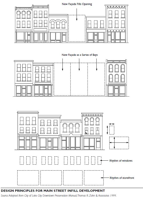
Height and Bulk
The height of most buildings within a main street should be relatively constant, although maintaining the typical minimum height of two or three stories is more critical than establishing a maximum height. Building scale and proportions should also be consistent. Wide buildings should usually be divided into separate bays consistent with the prevailing storefront rhythm.
Setback
Buildings should be flush with the sidewalk, except for small setbacks for entries, courtyards, or outdoor seating areas, to engage pedestrian activity and encourage drivers to slow down and watch for pedestrians and parking cars.
Door and Window Openings
The typical storefront has a high proportion of transparency from ground-level display windows and doors, and this should be maintained in newer buildings. The proportions of door and window openings in traditional main street buildings tend to be relatively constant. Keep proportions and height of upper-floor window placement consistent with the existing pat- tern, to reinforce a strong horizontal relationship between upper-story windows along the block.
Roof Shape or Profile
Roof profiles are usually consistent throughout the main street. Whether most buildings have the typical flat roofs, mansard roofs, or another shape, maintain consistent profiles.
Streetscape Design
There are numerous streetscape elements and design details that are desirable for main streets. These elements create a visually rich and inviting environment and provide visual cues and signals for motorists that they are entering a pedestrian-dominated district.
Street Trees
Street trees are effective visual signals. Along with the overall building density and scale, they can help define the main street district. As they mature, they create a canopy over the street, providing shade and aesthetic appeal.
Lighting
Lighting along the corridor should be geared toward pedestrians, to encourage main street activity into the evening hours. To have a significant effect on the appearance and sense of safety of the area at night, lampposts should be between 10 and 12 feet high. They can be installed in addition to, or in place of, taller road-illuminating fixtures.
Wayfinding Systems
Wayfinding signs can be used to direct visitors to the main street from regional highways and assist them in navigating within the district and other parts of the community. Such signs also promote the area’s identity and sense of place. Businesses can use this identification system for cooperative district advertising and event sponsorship.
Open Spaces
Public or semipublic spaces such as plazas and pocket parks are important main street elements. Relatively small areas adjacent to a sidewalk can bring life to the street and nearby businesses. Open spaces should be highly visible, adjacent to or bisected by the main stream of pedestrian flow; provide ample seating, shade, and weather protection; and offer a focal point, such as a fountain or gazebo.
Other Elements
Other visual signals that may be used in a main street area include hanging planters and window boxes. Space should be provided on sidewalks for display boards, benches, trash receptacles, drinking fountains, and bike racks.
Parking
Main street parking must meet the needs of customers, merchants, employees, visitors, and residents. It should be regulated, to encourage turnover of customer spaces and to discourage abuse by long-term parkers, and it should be accessible to handicapped visitors.
There are many ways to create parking areas that meet these objectives without adversely impacting the character of the main street.
On-Street Parking
On-street parking spaces usually turn over most rap- idly. Parking in these spaces is generally limited to two hours or less, as they are intended for use by customers making short trips. These spaces can be angled or parallel. The traffic movements involved in on-street parking help to calm traffic, while the parking itself creates the perception of a narrower street.
Parking Lots
Parking lots tend to accommodate long-term parkers, such as employees, more effectively than on-street spaces. Shared parking in a convenient location can also create a “park once” environment for the visitor. Parking lots can be located behind the main street storefronts with alley access, on an adjacent block near the main street core, or, in the busiest locations, in satellite locations served by shuttles. In general, parking lots should not be located in the typical commercial strip configuration, between the street and a building’s front door. Small parking lots between buildings may be acceptable if no alternatives exist, but should continue the street wall by means of an attractive fence, masonry wall, or hedge.
Structured Parking
Structured parking may be publicly or privately owned and operated. Constructing a parking structure is significantly more expensive than surface parking spaces. In main street areas that have a parking shortage, however, constructing a parking structure in an unobtrusive location is often preferable to demolishing buildings to create new surface lots. Parking structures can be combined with “liner” storefronts around their perimeter, and even with residential uses on upper floors.
Traffic
Traffic is a critical element of a busy, vital main street, and should be managed so that it is an asset. This can be done through controlling the speed through the corridor and the nature of the trip.
Many urban main streets are designed to accommodate traffic at 25 mph, but many suburban main streets are on arterials designed for 45 mph traffic. Sometimes, the main street is also a state highway, carrying a heavy volume of regional traffic. The on- street parking and streetscape improvements mentioned above, as well as physical traffic-calming devices such as curb extension, can be used to slow traffic and improve pedestrian safety.
Pedestrian Connections
Sidewalks are a common element in older or urban main streets, but are lacking or appear only sporadically in many newer suburban districts. Sidewalks should always be provided, to define a pedestrian space where there is no threat from moving cars; they should ideally be at least 10 feet wide to provide room for intense pedestrian activity as well as streetscape elements.
Pedestrian connections among uses can be as important as the traditional sidewalk route along the street. Walkways from rear parking areas are important for pedestrian wayfinding and safety. In suburban settings where some buildings may be set back from the street, a secondary pedestrian system between parking lots and in front of buildings can improve pedestrian circulation.
Bicycles
Cyclists are often overlooked as potential customers. Provide bicycle parking and dedicated bike routes to make the main street safe and convenient for cyclists, thus encouraging people to mix errands and exercise and expanding the customer base.
Transit
Many main street areas are served by transit systems. Comfortable accommodations for transit riders, including seating, transit shelters, and signage for transit stops, will encourage them to linger and shop.
PUBLIC/PRIVATE PARTNERSHIPS
When considering main street enhancements or improvements, public and private investments need to be linked. A key public investment often will attract additional private investment. Joint facilities, such as public parking lots, may allow private lots to be turned into buildings or open space. Street improvements, when combined with pedestrian improvements, can improve both traffic and pedestrian activity within the main street area. It is essential to involve all public and private partners when developing and maintaining a successful main street.
Mixed-use developments create vibrant urban environments that bring compatible land uses, public amenities, and utilities together at various scales. These developments seek to create pedestrian- friendly environments, higher-density development, and a variety of uses that enable people to live, work, play, and shop in one place, which can become a destination.
TYPES OF MIXED-USE DEVELOPMENT
Mixed-use development can take many forms but is typically categorized as vertical mixed-use buildings, horizontal mixed-use sites, or mixed-use walkable areas.
Vertical Mixed-Use Buildings
Vertical mixed-use development combines different uses in the same building. The lower floors generally have more public uses, with private uses on the upper levels. Examples include residential space over commercial establishments, street-level retail with an office tower above, residential and hotel uses in the same building, and retail and parking structure with multiple uses above. Vertical mixed-use development can have any number of revenue-producing and mutually supportive uses in the same building.
Horizontal Mixed-Use Sites
Horizontal mixed-use development combines single-use buildings on distinct parcels in a range of land uses in one planned development project. This approach avoids the financing and code complexities of vertical layered uses while achieving the goal of place making that is made possible by bringing together complementary uses in one place.
Mixed-Use Walkable Areas
These developments combine both vertical and horizontal mix of uses in an area ideally within a 10-minute walking distance or a .25-mile radius of a core of activities.
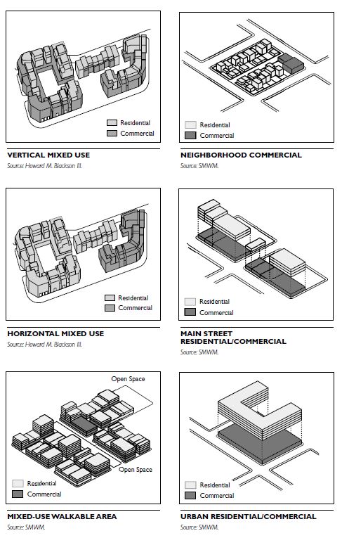
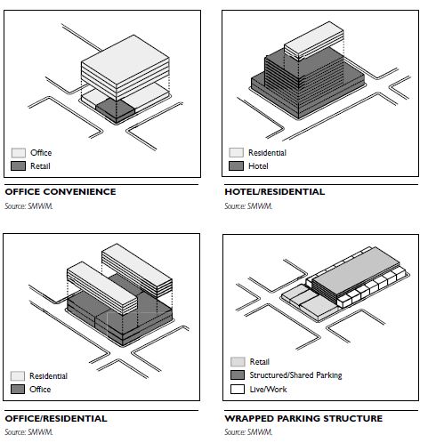
MIXED-USE COMPONENTS
Included here are diagrams showing various possibilities of mixes. These are not meant to be exhaustive but rather suggestive of the many ways one can consider mixing uses.
OBJECTIVES OF MIXED-USE DEVELOPMENT
Mixed-use developments contribute to the creation of places that enliven urban districts while meeting the everyday needs of the community. They offer many advantages over single-use districts in fostering better urban environments, some of which are described below.
Vitality
Place making has been one of the greatest achievements of mixed-use development. By revitalizing and diversifying urban areas such as downtowns, water-fronts, transit nodes, and infill sites, these developments become community destinations.
Sustainability
Mixing uses and allowing for higher development intensities creates more efficient and less consumptive buildings and spaces, which can be less of a burden on the environment.
Sense of Community
Mixed-use developments cater to a diversity of people and uses in one place, thus providing opportunities for community interaction.
Convenient Access
The proximity of diverse uses makes it possible to reduce vehicle trips and encourage transit ridership. Mixed-use developments can support higher transit use and may be a catalyst for siting transit facilities in the area.
Pedestrian-Friendly Environment
Mixed-use developments provide more opportunities for convenient and safe pedestrian access.
Sharing of Utilities and Amenities
Mixed-use development can result in more efficient use of land and infrastructure. For example, retail uses can share parking facilities with residential uses, because their peak hours for parking do not overlap substantially; thus, the cumulative parking requirement could be appreciably reduced. Similarly, stormwater facilities; sewer; common area maintenance; and central heating, ventilation, and air conditioning can be shared among various uses.
Longer Hours of Active Street Life
The range of uses can be active at different times of the day or on different days of the week, which activates the place for longer hours than is possible for any one single use.
Safety
Mixing residential, commercial, and professional activities within a compact area ensures activity throughout the day and evening, creating a sense of safety. For example, the presence of people living in apartments above stores helps reduce the potential for vandalism during off-hours, because, for all intents and purposes, there are no off- hours.
Historic Renovation and Adaptive Reuse of Structures
Renovating historic buildings and using them in new ways helps preserve the older urban fabric while providing architectural diversity in mixed-use developments.
DEVELOPMENT PARTNERSHIPS
Mixed-use development often involves both private and public sectors, and thus benefits from the efforts of the partnership. The two sectors generally have a few differing objectives, however. The private developer generally has financial gains to pursue, whereas the public sector is concerned with social gains for the community at large. Sharing the risk between the public and private sectors can also be beneficial.
CHALLENGES TO MIXED-USE DEVELOPMENT
Each community may present a set of challenges to creating mixed-use development. The following is a discussion of the obstacles typically faced.
Zoning Ordinances
In many communities, zoning ordinances favor single-use districts, making it difficult to implement mixed-use development. Conventional zoning typically allows for one single quality or function in an area at the exclusion of all others; some communities do allow for cumulative zoning, however, where uses with lesser impacts are allowed in higher-impact zones (e.g., residential allowed in commercial zones). At the district, neighborhood, and town center scale, one dominant building function, use, or type creates a less vibrant and engaging experience. Mixed-use developments can be made possible by modifying the zoning ordinance to accommodate a broader range of compatible uses. For example, consider changing a single-use district to either a planned unit development (PUD) district or an overlay district to allow for a mixed-use development.
Financing
Private sector investment and subsidies for mixed-use development are often more complicated and more difficult to obtain than conventional developments because mixed-use projects are not as commonly pursued; therefore, there are fewer established pro- grams for them. Heavier up-front costs often further deter financing institutions from lending money for mixed-use developments. Developers of mixed-use projects often have to be creative in assembling the necessary financing. A partnership with a public agency may make public funding sources available to increase project feasibility or offer support in the early stages.
Layering
Layering uses, as in vertical mixed-use development, increase the development cost and the associated risk. Mixed-use developments can cause planning and management complexities that might not other- wise exist in a single-use project. Developers need to be aware and well informed of the timeline and cost implications from the onset of the project, to help reduce the complexities that would evolve otherwise. Up-front efforts to inform local code officials of the methods and conditions for mixed-use project review can be beneficial.
Transit-oriented development (TOD) is generally defined as development that is located within a 10- minute walk, or approximately .5 mile, from a light rail, heavy rail, or commuter rail station. It also includes development along heavily used bus and bus rapid transit corridors. In some communities, waterborne transit supports TOD.
A mix of uses, including housing, retail, office, research, civic, and others, characterizes TOD projects. TOD also involves development at higher densities than typical, to take advantage of transit proximity and planning and design elements that encourage walkability and create pedestrian-friendly connections to the surrounding community. TOD projects range widely in size, from infill loft developments to mixed-use centers to entire new communities.
Many communities have limited opportunities for TOD, because land areas within the half-mile radius have already been developed, transit is not yet an available transportation option, or potential development sites are not of a suitable size for TOD. Most TOD projects contain at least 100,000 square feet (or 60 to 80 housing units), and many are far larger. TOD can be developed at a smaller scale, but such projects often have more difficulty absorbing the costs of creating a pedestrian-friendly public realm. That said, economic benefits often accrue from reduced parking requirements and increased densities. When potential TOD sites become available, communities should be ready to take advantage of the unique potential they offer.
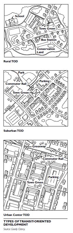
BENEFITS OF TRANSIT-ORIENTED DEVELOPMENT
Certain benefits of TOD make it distinct from conventional development approaches. These benefits are numerous and include quality of life, public health, economic development, community character, environmental quality, and transit use.
Quality of Life
Transit-oriented development can result in many quality-of-life benefits, including reducing automobile dependency; increasing the range of housing options, both the types of housing and the range of afford- ability available to a community; and enhancing the vitality of neighborhood main streets and centers.
Public Health
Because transit-oriented development reduces auto-mobile dependency, residents can take advantage of a more walkable environment. Reduced vehicle trips also result in improved air quality.
Economic Development
Transit-oriented development provides affordable access to jobs for people without automobiles or with fewer automobiles per household, attracts employers to locate around station areas, and broadens the over- all tax base.
Community Character
The increased density in TOD projects provides opportunities to create public spaces and well-designed buildings that give identity and vitality to those spaces.
Environmental Quality
In addition to the public health benefits, transit-oriented development provides a design alternative to sprawl, and is an opportunity to pursue environmentally sensitive site planning and “green” architecture.
Transit Use
Increased ridership and the potential for additional funding sources for new transit facilities are among the transit benefits of TOD.
SITE PROGRAMMING
When developing an overall site program for a transit-oriented development, four principles for achieving optimal use and function of the site should be considered:
Build Densely
One of the primary characteristics of transit-oriented development is an increased level of density as com- pared to conventional development. Building to a higher density lets one take advantage of reduced auto dependency, make efficient use of TOD sites, support pedestrian-friendly shops, and create lively, people-filled environments. Locating between 1,500 and 2,500 housing units within walking distance can support a new block of “main street” retail space, according to a 2002 study by Goody Clancy and the real estate firm of Byrne McKinney.
Some representative TOD densities include the following:
Mix Uses
Along with higher densities, transit-oriented development can also be characterized by the emphasis on a mixed-use environment. To create such a dynamic, enliven sidewalks and public spaces with as much retail as the market will support, provide tax revenue- generating and job-producing commercial development, and provide opportunities for residential to be located adjacent to or above such uses. This intentional programming can reinforce the vitality of town centers and main streets, where transit stations are often located. The decision to include residential above or adjacent to commercial and office uses will depend upon economic feasibility, market forces, local preferences, or other factors. Examples of variety in mixed-use projects include the following:
Mix Housing Types and Prices
Take advantage of creating housing at higher densities to increase the diversity of housing in the community, including affordable housing. According to the Urban Land Institute (ULI), the share of house- holds with children looking for housing will drop significantly by 2025, producing demand for a wider range of housing options.
Reduce Parking Requirements
One of the most important outcomes of transit-oriented development is increased transit use. Lower parking requirements and dedicated bicycle paths and bicycle parking are among the actions that can be taken to achieve this. The higher density and land values of TOD often make it feasible to construct structured parking or below-grade parking in place of surface lots. Lower parking ratios reduce overall project costs. Mixed-use projects can further reduce parking requirements by enabling shared parking, such as office workers during weekdays and residents during evenings and weekends. Here are some representative TOD parking ratios in different parts of the United States:
SITE DESIGN
Within a transit-oriented development site, the fol- lowing design features should be emphasized in the site planning process.
Pedestrian Access
Provide convenient, direct, and public pedestrian access to transit through TOD projects. Create continuity with local streets, and locate retail and other pedestrian-friendly uses to encourage pedestrian flow to nearby commercial districts and main streets.
Public Spaces
Create new public spaces, including lively streets, squares, and parks, that enhance nearby commercial districts. Take advantage of the increased pedestrian activity generated by both transit and TOD. Relate the new spaces to public and semipublic uses that may also cluster at TOD locations.
Sense of Place
Create a sense of place by orienting buildings and public spaces to create a strong sense of identity for the development, and by using buildings to frame public spaces. Consider design guidelines or standards that celebrate these places. Pedestrian Experience
Foster an enriched and invigorated pedestrian experience. Include retail and other pedestrian-friendly uses. Maximize windows and entries to build a sense of connection between pedestrians and activities within buildings. When surface parking is needed, locate it on the side or rear of buildings. Visually screen parking areas with vegetation or create urban blocks that allow for screening of parking structures with residential units or retail on the street level.
Character and Quality
Enhance the quality and character of surrounding communities. Allow for well-designed buildings that emphasize place making. Orient buildings to new and existing streets and squares. Use transitions in height and massing to respect, but not mimic, the fabric of nearby districts.
Architecture
Encourage architecture that reflects transit’s civic importance, creating buildings that, regardless of architectural style, employ materials and design that convey a sense of quality, permanence, and community-enriching character.
Sustainability
The combination of transit use and intense development around transit stations is one of planning’s most powerful policies for long-term sustainability. Plans, guidelines, and development approaches should work to reinforce this use and intensity. On a building or project scale, build for sustainability, including site and building design, which reflects a commitment to environmental responsibility. This should include the following:
- Green site design that reflects environmental issues such as minimizing impervious surfaces and maximizing sunlight on public spaces.
- Green building design that uses materials and design principles that minimize the use of nonrenewable resources and maximize energy conservation.
PUBLIC/PRIVATE PARTNERSHIPS
TOD often involves public/private partnerships. Involvement of the public sector implies greater responsibility to create projects that promote community goals. In many cases, the public sector must make initial investments to create a site adjacent to a transit station, contribute publicly owned parking lots, or invest in new local access to the TOD site. Where the private sector controls a TOD site, it is often necessary to collaborate on planning and design to create appropriate connections between development and transit.
Transit proximity often increases real estate values, and TOD projects often can afford the cost of public benefits. Studies show that property values within .25 miles of DART stations in Dallas were roughly 25 to 50 percent higher than comparable properties. Arlington County, Virginia, has used density bonuses, often 15 to 25 percent, to fund increased affordable housing and other benefits adjacent to transit. Massachusetts and other states have taken this concept a step further and have proposed that transit-oriented developments help fund new transit initiatives.
IMPLEMENTING TOD
TOD sites often have complex programs, hence require significant planning. It is often the lack of planning, rather than the lack of market demand, that slows or blocks a transit-oriented development. Several mechanisms can be used to address this. Partnerships
Create effective planning partnerships that include the transit agency, local government, other appropriate public agencies, the community, and the development team.
Planning Study
Conduct a planning study to determine how the TOD should be physically, socially, economically, and culturally integrated into a community. Resolve issues such as parking, site access, relationship to existing neighborhoods and commercial districts, and similar concerns. Identify initial public investments in land acquisition or infrastructure that need to precede significant private investment. The study should also identify zoning and other regulatory hurdles that need to be resolved.
Participation
Establish an effective community participation process that reflects the major role that TOD can play in shaping a community’s future and TOD’s unique civic dimension.
Design Guidelines
Given the civic nature of TOD, design guidelines and ongoing planning and design review are quite important. If such review processes are not in place, consider establishing review procedures that rein- force these places through massing, materials, lighting, and similar design features.
CONSERVATION DEVELOPMENT
When a property is developed as a residential subdivision, an opportunity exists to add land to a communitywide network of open space. Conservation development focuses development on each parcel as it is being planned so at least 50 per- cent of the buildable land is set aside as open space. The same number of homes can be built in a less land-consumptive manner, allowing the balance of the property to be permanently protected and added to an interconnected network of community green spaces. This “density-neutral” approach provides a fair and equitable way to balance conservation and development objectives.
CONSERVATION DEVELOPMENT APPROACH
Communities protect open space for numerous reasons, such as to protect streams and water quality, provide habitat for plants and animals, preserve rural “atmosphere,” provide access to nature and recreational areas, protect home values, and reduce costs of municipal services. To achieve these and other goals of open-space protection, the conservation development process involves three steps:
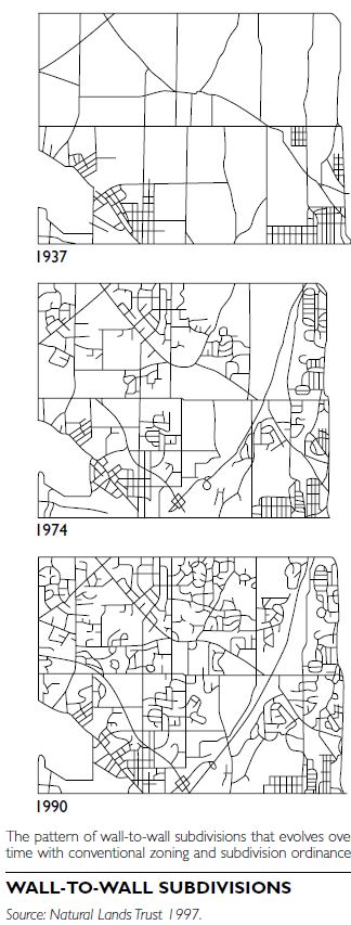
Community Assessments
The community assessment process helps local officials and residents see the ultimate result of continuing to implement current land-use policies. The process helps start discussions about how cur- rent trends can be modified to ensure a “greener” future.
Most local ordinances allow or encourage standardized layouts of “wall-to-wall” house lots. Over a period of decades, this process produces a broader pattern of wall-to-wall subdivisions. In many cases, this leads to the conversion of every unprotected acre of buildable land into developed uses.
Municipalities can perform community assessments to “see the future,” enabling them to judge whether a midcourse correction is needed. An assessment entails the following:
Open-Space Conservation Areas
Many communities have adopted comprehensive plans or open-space plans that contain detailed inventories of natural and historic resources. In order to create an interconnected network of open space, communities should draw a map of potential conservation lands. This map serves as the tool that guides decisions regarding which land to protect in order for the network to eventually take form and have sub- stance.
A map of potential conservation lands starts with information contained in the community’s existing planning documents. The next task is to identify two kinds of resource areas, primary and secondary conservation areas.
Primary Conservation Areas
Primary conservation areas comprise only the most severely constrained lands, where development is typically restricted under current codes and laws, such as wetlands, floodplains, and slopes exceeding 25 percent.
Secondary Conservation Areas
Secondary conservation areas include all other locally noteworthy or significant features of the natural or cultural landscape:
Local residents should be directly involved in the identification of secondary conservation areas. These resource areas are typically unprotected and are often zoned for some type of development.
Conservation Area Mapping
The primary conservation areas first are identified on a base map that includes lands that are already protected, such as parks, land trust preserves, and properties under conservation easement. Each kind of secondary conservation area is then laid on top of the base map, using clear acetate sheets or a geographic information system (GIS), in an order that reflects the community’s preservation priorities, as determined through public discussion.
This overlay process will reveal certain situations where two or more conservation features appear together, such as woodlands and wildlife habitats, or farmland and scenic viewsheds. It will also reveal gaps where no features appear. This exercise is not an exact science; nevertheless it frequently helps local officials and residents visualize how various kinds of resource areas are connected to one another. It also enables them to tentatively identify both broad swaths and narrow corridors of resource land that could be protected in a variety of ways.
CONSERVATION SUBDIVISION DESIGN
Conservation subdivision design devotes at least 50 percent of the buildable land area within a residential development to undivided permanent open space. The most important step in designing a conservation subdivision is to identify the land to be preserved. The communitywide map of potential conservation lands can be used as a template for the layout and design of conservation areas within new subdivisions, helping to create an interconnected network of open space spanning the entire municipality.
In order to design subdivisions around the central organizing principle of land conservation, ordinances need clear standards that guide the conservation design process. The approach described below reverses the traditional sequence of steps in laying out subdivisions. By requiring 50 to 70 percent open space as a precondition for achieving full density,officials can effectively encourage conservation sub- division design. The protected land in each new subdivision would then add new acreage to the communitywide open-space networks.
Identify Land for Permanent Protection Areas identified on the communitywide map of potential conservation lands are incorporated into the map of the potential development area. Primary conservation areas are identified first, followed by secondary conservation areas. Before incorporating these areas onto the map, a detailed site analysis should be conducted in order to precisely locate features to be conserved. After “greenlining” these conservation elements, the remaining part of the property becomes the potential development area.
Locate House Sites
Locate sites of individual houses within the potential development area to maximize their views of open space. The number of houses is a function of the density permitted within the zoning district, as shown on a yield plan. In unsewered areas, officials should require a 10 percent sample of the most questionable lots—which they would select—to be tested for septic suitability. Any lots that fail would be deducted,and the applicant would have to perform a second 10 percent sample. Connect Sites and Define Lots
The final step involves “connecting the dots” with streets and informal trails, and drawing in the lot lines.
OPEN-SPACE PROTECTION AND OWNERSHIP
A wide array of open-space protection tools are avail- able for the areas not to be developed in a conservation development. The most effective way to ensure they will remain undeveloped is to place a permanent conservation easement on the land. Land trusts and units of government typically hold easements. Other tools, such as deed restrictions and covenants, are not as effective as easements in protecting land in perpetuity, and they are not recommended for this use. The ownership of the conservation land may occur as one of four options:
INFILL DEVELOPMENT
Infill development occurs on vacant or underused lots in otherwise built-up sites or areas. Infill projects can take several forms, such as a small addition in a residential backyard, a single-lot development, a brownfield development, or multiparcel projects in urban downtowns.
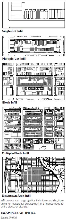
GOALS AND BENEFITS OF INFILL
Infill strategies have many benefits. They can:
- preserve open space, agricultural land, and forests by reducing development pressures on greenfield sites;
- provide opportunities to revitalize a neighborhood or downtown;
- increase the tax base for a jurisdiction by creating or renewing a property’s value;
- make efficient use of abandoned, vacant, or under-used sites;
- enhance sustainability by making efficient use of existing community amenities and infrastructure;
- promote compact development and increase density; and
- create a mixture of uses.
ISSUES TO ADDRESS FOR INFILL PROJECTS
Among the issues to address when considering infill are the existing zoning regulations for the area, the condition of the infrastructure, site acquisition and development financing, parking requirements, and community concerns.
Existing Zoning
A preexisting neighborhood is typically regulated by an existing zoning ordinance and other codes. These regulations may be restrictive or permissive toward creating infill development. Check with local plan- ning departments to identify regulations that may be in conflict with infill projects or, conversely, those that might facilitate such development. Successful infill projects work within the existing regulatory frame- work and demonstrate how to provide alternatives that fully use the zoning allowances.
Infrastructure Condition
Developers of infill projects often face deteriorating infrastructure or capacity limitations in older areas of a community, and infrastructure upgrade or replacement can be expensive. Thoroughly inspect the existing infrastructure to ensure the project’s budget can support the required upgrades.
Acquisition and Development Financing
Concerns over the financial feasibility of infill development can sometimes halt a project. Funding redevelopment in urban areas can be complex when it involves elements of mixed-use development and different building scales within an area. Banks may be reluctant to lend money, and developers may experience high land costs and potential environmental cleanup costs, especially on sites in older communities that have had several uses over the years.
An infill project’s strength lies in the potential to increase the market value of an existing area. Infill projects that receive adequate funding are typically the ones that:
Parking
Understand the parking requirements for the area. Often, new parking requirements within an already developed area are difficult to satisfy with infill projects, due to limited land availability. Ensuring a project meets the parking requirements without burdening the streets with additional demand for on-street parking can also be an issue. There are a number of strategies to overcome parking issues:
• Encouraging shared parking between uses and institutions. • Reducing parking requirements in mixed-use or transit-oriented areas. • Incorporating transit programs into the development. • Implementing a day/night use of parking, such as allowing parking for businesses in the daytime, than in the evenings for local entertainment venues or residents.
Community Concerns
Local opposition may pose challenges for infill development. The level and type of opposition depends on the neighborhood’s character and history, among other factors. A common concern raised by surrounding residents is that an infill project may adversely affect their property values and may increase burdens on local resources such as streets, parking, schools, and other public amenities. One of the ways to address this situation is to involve the community in the design process through workshops and other public outreach programs.
ANALYSIS OF SITE CONTEXT
The following are various elements of the existing conditions to address when planning for infill development.
Neighborhood Character
Successful infill projects create harmonious relation- ships between the proposed and existing surroundings, enhancing the unique qualities of the neighborhood through functional and visual relation- ships. Carefully plan uses within a neighborhood to avoid clashes of incompatible activities, and study existing façades and streets to create guidelines that enhance those elements. Infill projects may also include rehabilitation of historic buildings and preservation of landmarks or significant public squares, which also preserve and enhance the special character of an area.
Patterns
Take into account the block patterns of an existing neighborhood when creating infill projects. Patterns of a neighborhood include the streets and alleys and other connections used by residents. Consider the fabric of the neighborhood by studying the size of each block. By respecting the existing neighbor- hood’s scale and urban fabric, an infill project will integrate more successfully and create continuity, which in turns promotes community harmony.
Connections
Integrate an infill project with the existing land-use patterns through street networks, open-space systems, and other connections. Work to connect neighborhoods at multiple scales, from local pedestrian paths to regional patterns of transportation and open space. Because an infill project occurs within an existing area, it can either enhance or disrupt existing connections. Allow streets and alleys to continue, and avoid disrupting existing vital connections.
Amenities
To further integrate infill development into a neighborhood, identify and make use of important existing amenities, such as transit nodes, retail zones, and other public resources. Increase neighborhood value by building on existing amenities, such as open space, transit centers, and other amenities.
STRATEGIES FOR INFILL DEVELOPMENT
Diversity
Promote a mix of uses, including housing, retail, and commercial uses, both horizontally and vertically. Blend housing with other uses to create neighborhoods and districts where people are present at all hours, a key element of public safety and community liveliness.
Density
Successful infill development is often dense enough to make transit viable and support walkable retail districts. Higher densities create the sense of a strong, residential enclave, and can help to deliver the critical mass of residents essential to support commercial and retail uses, whether existing or part of the infill development.
Transit
Transit, when available, is key to infill development. To achieve strong ridership, transit systems need significant densities. Infill projects can increase ridership on existing systems and make transit an even more viable option. Create infill development that responds to existing transit lines, supports a walkable environment, and makes local services accessible to and from transit stops.
Scale
Take into account the grain and scale of existing frontages, sidewalks, streets, and building façades, and the massing of the surrounding area. Infill projects that take this approach often create a coherent neighborhood that responds to various scales of living, from the pedestrian to the larger, more public scales, such as major retail or commercial corridors. Replicating surrounding structures is not required, but, often, compatibility must be demonstrated.
Massing and Articulation
Consider the relationship of the infill project’s massing to that of the existing area to ensure minimal impacts to solar access, wind conditions, and other factors. Strategies to address this include articulation in massing and materials to create interest and break the monotony of a larger façade. Successful massing strategies promote interaction between the sidewalk pedestrian and the building by creating a street frontage that is appropriate at the ground level. Maintaining a consistent urban edge is also an important massing consideration.
Consistent Façade
Maintain ground-floor façade within an infill project to define a consistent street edge.
INFILL PLANNING FRAMEWORK
Among the key elements of the infill planning frame- work are phasing, community involvement, and design guidelines.
Phasing
For large-scale infill projects, phasing allows projects to be built in multiple steps. It promotes incremental growth, so that the additional population will not unduly strain the community’s ability to provide public facilities and services. It also provides the time and capacity necessary to absorb growth into the overall neighborhood. A carefully planned phased development allows the real estate market to adjust to it and expose the new projects to surrounding potential users.
Community Involvement
Public participation is often critical to the success of an infill project. Involve the public early in the development process to help guide projects and make the intent and goals of the project clear to them. Often, most critical are sketches that illustrate before-and- after conditions, and traffic analyses that provide methods to mitigate adverse impacts. Engage residents, civic leaders, and local institutions throughout the process of planning change for a neighborhood.
Design Guidelines
Where appropriate, develop design guidelines to serve as a guide for future development and ensure predictable and desirable growth.
Site analysis involves understanding the opportunities and constraints of a specific parcel of land for potential new uses. The process links a program for proposed uses with a site inventory of its key features through a site suitability analysis. Planners and urban designers use the site analysis process both to design specific parcels as well as to help implement land-use regulations. The typical components of site analysis are consideration of physical, biological, and cultural features. Information about these features is collected through a site inventory. Maps are used to record and to display site attributes from this inventory.
PHYSICAL FEATURES
The physical features of a site include its geology, physiography, hydrology, microclimate, and soils.
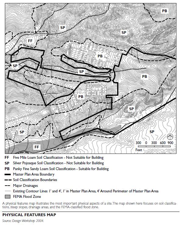
Geology
A geological map provides a graphic representation of the rock units and geological features that are exposed on the surface of the Earth. In addition to showing different types and ages, most geological maps depict features such as faults and folds. Geological information is helpful to determine the capability of the land to support various uses such as building foundations and roadways. In addition, geologic hazards can be revealed.
Physiography
Physiography deals with the physical conditions of the land surface. Elevation and slope are important physiographic features for site analysis. U.S. Geological Survey (USGS) topographic maps can be used to depict elevation changes across a site and to determine different slopes. Steeper slopes will present greater challenges for building than flat areas.
Hydrology
Hydrology includes both groundwater and surface water features. The hydrologic cycle helps planners to understand the balance of water in its various forms in the air, on the land, and in waterbodies such as rivers, lakes, and the sea. Groundwater fills all the unlocked pores of materials lying beneath the surface. Depth to the water table, water quality, aquifer yields, direction of flow movement, and the location of wells are important groundwater factors for site inventories. Surface water flows above the ground. Some surface water characteristics are useful for site inventories:
Often, local land-use and environmental regulations require specific mapped information for a site, such as the location of floodplains.
Microclimate
Microclimate involves small-scale variations in temperature brought about by changes in slope and orientation of the ground surface; soil type and moisture; variations in rock, vegetation type, and height; and human-made features. Some microclimate inventory elements for site analysis include the following:
- Ventilation
- Fog and frost frequency and location
- First and last frosts
- Solar radiation
- Surface condition albedos (level of reflected light) and temperatures
- Vegetation changes
Urban heat islands are important concerns in many places; a site analysis can help to mitigate the negative climatic impacts of new land uses. For example, black asphalt will heat up an area more than trees.
Soils
Soils occupy a transition zone that links the biotic and abiotic environments. Soil is a natural three-dimensional body on the surface of the Earth that is capable of supporting plants. Its properties result from the integrated effect of climate and living matter acting upon parent material, as conditioned by relief over time. The Natural Resources Conservation Service (NRCS) of the U.S. Department of Agriculture has mapped most soils and has made them available in published soil surveys as well as in digital formats. NRCS soil surveys contain special information helpful for site analysis including: permeability, texture, erosion potential, drainage potential, soil associations, cation and anion exchange, and acidity-alkalinity. This information is helpful to determine the capability of soils to support various uses, such as roads, parks, buildings, and farms.
BIOLOGICAL FEATURES
Various plants and animals occupy each site. Vegetation refers to plant life—trees, shrubs, cacti, herbs, and grasses. Plant associations and communities; vegetative units; wildfire susceptibility; and rare, endangered, and threatened plant species can be mapped in a site inventory. In addition, lists of species, including their composition and distribution, can be compiled. For some sites, drawings of physiognomic profiles, as well as ecotone and edge profiles, can be used to illustrate site-specific vegetation. Physiognomic profiles show the structure of plant communities in profile relative to their location on a slope. Ecotones are transitional areas between two ecological communities, generally of greater richness than either of the communities they separate. Broadly, wildlife is considered to be animals that are neither human nor domesticated. The potential habitat of wildlife species and its relative value can be mapped. As with vegetation, lists of animal species, including their composition and distribution, can be created. Understanding the plants and animals of the site can help planners and urban designers to protect other living creatures. In addition, plants and animals provide amenities for some land uses.
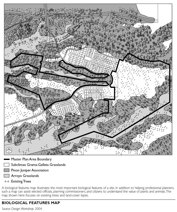
CULTURAL FEATURES
Existing land use refers to the physical arrangement of space utilized by humans. A specific parcel of land can be used for a variety of purposes, and a particular person in a given location may use many parcels of land.
An important component of site analysis is an understanding of both past and existing use. The history of a place can be gathered from various sources, including interviews with older residents and research in community and academic libraries. The past history of a site might be a legal requirement if the property was used for a purpose resulting in pollution or contamination. Understanding a history of a place can reveal how and why its settlement patterns have evolved. One purpose of site analysis is to make new uses compatible with existing settlements. Such settlements are composed of buildings and open spaces with specific arrangements of plots, lots, and streets. A figure-ground map can help illustrate the relationships between buildings and open space.
Site inventories often involve an evaluation of visual quality. This can focus on potential users’ preferences for site amenities. The best views from various locations on a site can be mapped. Planners and urban designers can use these vistas to locate uses to optimize those views. Site analysis can also help planners protect visual qualities. Unseen site characteristics can be important as well, such as the location of utility lines and easements.
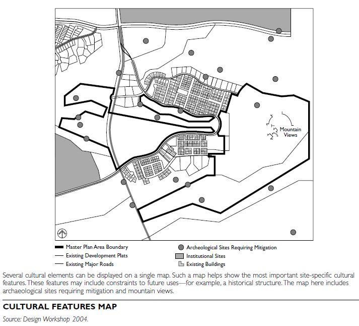
SITE SUITABILITY ANALYSIS Land suitability is the process of determining the fitness, or the appropriateness, of a given tract of land for a specific use. It is based on the site inventory as well as the program for future potential uses. Suitability analysis balances opportunities for those uses with site constraints. There are seven steps in suitability analysis:
Geographic information systems (GIS) can assist planners and urban designers in the site inventory mapping and suitability analysis processes. A GIS allows planners and urban designers to consider multiple rankings of mapped information for site suitability.
SITE ANALYSIS IN PLANNING AND URBAN DESIGN
Planners and urban designers use site analysis for a broad range of purposes. It can be used to change the use of a parcel from farming to housing or a shopping center. It can assist in siting transportation facilities as well as for the layout of conservation areas. Site analysis can also be utilized in existing built-up areas to determine new uses. The nature of the proposed land use and the site will determine the specific features to be inventoried and mapped.
An issue planners often face in site analysis is the availability and the scale of mapped information. Important site-specific data for a proposed land use may be lacking or available at an unusable scale. In such cases, planners will need to create new information, which can be costly. Improved GIS, Web-source information, and remote-sensed imagery help overcome this issue. Continued emerging technologies are likely to improve site analysis techniques further.
Site analysis is a fundamental component of site planning. A thorough analysis of a place enables the planner to link conservation and development goals to site-specific characteristics.
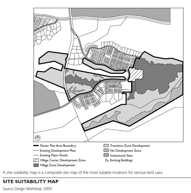
Urban analysis links an understanding of a place and its context with generally acceptable urban design concepts and strategies. Whether the place in question is a specific site, a city street, a neighborhood, downtown, or a region, a thorough understanding of the place helps guide the choice of the most appropriate type of project. The type of analysis chosen should help to better understand a project’s location and context; it should not be used to support a desired outcome or predetermined design. Any type of urban analysis needs to begin with the project goals. Understanding the goals and what the client, the city, the developer, or the citizens hope to achieve through the project can help determine the most appropriate type of analysis for ascertaining the project’s potential for success.
The process of analyzing the physical environment in urban, suburban, and rural areas can be performed on many scales. Projects can be proposed for a range of sizes, from an individual building site to entire regional areas. The size of the proposed project or study area should dictate the scale of analysis. For example, a single-site project would warrant an analysis of the surrounding neighborhood, while a plan or project for a large, multisite area would involve analyzing the surrounding neighborhoods or larger regional area.
STANDARDS AND REGULATIONS
Several individuals have developed nationally recognized guidelines for urban analysis, including Kevin Lynch, Christopher Alexander, Colin Rowe, and William Morrish, among others. Architects or urban designers developed the majority of these individually created guidelines, so they tend to present simplified categories that focus on the physical character of a place. For a more accurate and balanced understanding of a site, include a wider range of factors, among them economic data, environmental issues, and transportation concerns.
On the federal level, there are two key nationally recognized standards regulating the types of urban analysis undertaken for a particular project. First, there are standard requirements for nominating a place for the National Register of Historic Places, which the National Park Service administers. Second, the National Environmental Policy Act (NEPA) has standards that require certain types of analysis as part of an environmental review process.
ELEMENTS OF URBAN ANALYSIS
There are many types of analysis that can be performed, but they can be organized into six general categories: community, regulations and ownership, continuity, character, connections, and economics and market setting. Each category includes several different elements that can be examined, including the key reasons to study each element and the best way to perform the analysis.
Community
Key elements of the community to explore include census information, previous planning efforts, and public processes.
Census Information
Although U.S. Census data do not include individual or collective values, they do provide an overview of the demographic character of the residents in a particular community. Statistics available for analysis include age, employment, income, household size and tenure, and commute distance. Census information (available online at www.census.gov) can be analyzed through a series of summary charts and/or bar charts. In addition, many municipalities provide demographic summaries of their communities on their websites.
Previous Planning Efforts
Previous plans may also be a resource to investigate. Understanding why previous plans were or were not successful, as well as what kind of public support they garnered, can help guide future projects and may help in establishing community values. Previous plans can be analyzed by reading through draft and final reports, interviewing the previous project’s or plan’s client, city officials or city staff, or planning and design consultants who prepared the plan. The plans can be summarized through a series of maps, with annotations of key improvements and key obstacles to implementation of the plan.
Public Process
A community’s perception regarding itself and its environment is an important element to gauge. No matter what the physical or economic analyses say about a place, for a project to be successful, it needs the support of people who live, work, and play there. Decision makers and citizens often have specific goals and desires for projects, so it is critical to meet with them individually before a project commences. Local decision makers have more direct sway over the success of an individual project, but, today, individual citizens can effectively halt almost any project, so it is important to invite all relevant stakeholders to the table to help ensure a successful project.
Various types of interactive public processes can be used to solicit the public’s ideas and viewpoints regarding their community. Two commonly used tools are visual preference analysis, whereby the public identifies what they like and do not like about images of places, and interactive mapping exercises, whereby people use different “game pieces” that rep- resent land uses or other physical elements to map suggestions and improvements for an area. (See Public Meetings in Part 1 of this book for more information and examples.)
Regulations and Ownership
Zoning and Land Use
Documenting the zoning classifications both within and surrounding a project area or site will define the existing potentials for use, along with the building envelope and densities within which those uses can be built.
A record and analysis of zoning regulations is sup- ported by a variety of drawing techniques, starting with a plan drawing that indicates the allowable land uses and densities within and surrounding a site. Plans or section diagrams are useful for illustrating allowable development characteristics such as building heights, floor area ratio (FAR), allowable residential densities, building setbacks, and parking requirements. A map of existing land uses should be independently prepared and compared to the uses allowed by zoning. (See Zoning Regulation in Part 6 of this book for more information.)
Design Guidelines
As a supplement to zoning codes, many municipalities have established design guidelines to shape the architectural character of their communities. Design guidelines that clarify and recommend elements such as windows and doors, private plantings, building and roof shapes, and signage are an appropriate starting point for the definition of character in a proposed development.
Design guidelines are typically represented through drawings and photographs of buildings (both within the community and from outside) that describe the appropriate type of building for a particular site, street, or community. A summary map or memo can illustrate the implications of such guidelines for a particular site or area.
Property Ownership
The type and character of buildings in a place con- tribute to many important aspects of a community, and in some cases may be a direct result of the pat- terns of property ownership. Property lines, property ownership, and the shape, pattern, and size of parcels are key factors in the built environment’s appearance. The patterns of land ownership—such as public versus private owners, multiple owners for multiple properties, single owners for multiple properties, and small-scale lots versus larger “super blocks”—can be a strong indicator of the likely pat- tern of urban form.
Multiple ownership projects, including public/private partnerships, are becoming more common. Therefore, documenting all the relevant property lines and ownership is important to identify the contribution of various parties and guide the balance of development funding and investment returns.
Property lines and ownership can be analyzed through parcel maps. Much of this information can be found in Sanborn fire insurance maps , city planning departments, subdivision plat files, county land and tax records, and even historic maps. This information is not always readily available in digital format, however, or if it is, it may be from scans of original hard copies, which may have limited enlargement capability for diagramming purposes. Some communities keep this information in a geographic information system (GIS) database that ties property lines to property ownership, which can be easily used as a base for diagramming.
Continuity
Key elements of the continuity of a place to explore include history and patterns of development.
History
How a community has changed or remained consistent in physical patterns can reveal a lot about its character and its susceptibility for change. In addition to recognized historic areas, broaden the perspective to study the patterns of building, roads, and landscape features over time to understand how and why communities developed the way they did. Refer to state and federal guidelines for historic analysis of districts as a useful structure for such an analysis.
Mapping changes in the landforms and topography over time can indicate the location of historic shore-lines and wetlands or former agricultural lands, sensitive landscape features that have been lost, and remaining natural features that may merit preservation.
Patterns of Development
As communities develop over time, they often create unique patterns in the type, scale, and location of buildings. Figure ground diagrams, where buildings are dark shapes on a white background, and block pattern diagrams, where blocks of developable property are dark on top of a white street pattern, for different periods of time or different part of a community can help guide the scale, pattern, and even logical locations for future development. Similar in nature to a figure ground diagram, a Nolli Map, named for Giambattista Nolli’s groundbreaking map of 1748 Rome, is a useful tool for exploring the continuity of the perceived public space in a community. Whereas a figure ground diagram denotes the difference between built and unbuilt space, Nolli maps denote the public space both outside and inside buildings, such that the interiors of schools, city halls, and community centers, for example, read as part of the overall network of public space. This type of analysis can be helpful in understanding the use of ground floors of buildings to augment the public realm, providing guidance for future developments.
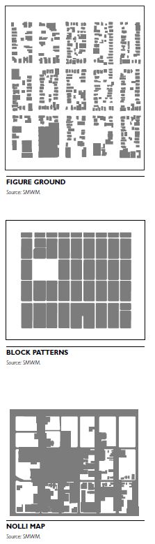
Character
There are several key elements of the character of a place to explore, including urban form, topography, views, open space, activity nodes, architectural character, streetscape, and the natural environment. Aerial photography is often a useful tool in providing a visual overview of the urban form and can be combined with line work over the aerial photograph as a successful diagramming technique for many of the elements described below.
Urban Form
Taken collectively, the scale and character of individual buildings and the topography of a place create an overall urban/built form. Analysis of urban form can highlight patterns ranging from the general shape of development to the integration with the larger natural environment.
Figure ground drawings and block pattern diagrams are useful tools in understanding the general scale and grain of development in a particular built environment.
Topography
Topographic features such as slopes or the presence of a floodplain can limit the type of development allowed in a place. A thorough understanding of the overall topography of a place is also useful for under- standing original settlement patterns and locating new development appropriately.
Analysis of the overall landform can be achieved with topographic maps that identify specific land- forms that limit development, such as hills or bodies of water, or areas that are suitable for development, such as areas of flat land. Such information should be supplemented with other environmental data, such as the location of aquifer recharge areas.
Views
The process of building cities and suburbs simultaneously frames views of the natural environment and creates a multitude of human-made views, from city skylines to residential tree-lined streets. Understanding which views are important, whether they are point views (views toward a single object or group of objects), panoramic viewsheds, or linear views can help guide the scale of development.
Important views in a community can be indicated on aerial photographs or base maps of a community, highlighting the different kinds of views and the subject of the view. Views and viewsheds can also be analyzed through section drawings, showing how street edges frame particular views and how the scale of development or the placement of buildings on a particular site can allow or block views to the surrounding landforms.
Open Space
The number of parks and other recreational and non- recreational open spaces is often a useful gauge for the number of residents a community can comfort- ably support. Various methods can be used for such an assessment. Diagramming the system of existing open spaces in a community can help guide the location of new parks and open spaces in a community. Open space can also be analyzed to document the ownership of open space in a community to ascertain if there is an appropriate balance between public and private ownership.
A plan drawing, indicating the different types of open spaces and ownership, is the most common type of diagram used to understand the open-space system in a community.
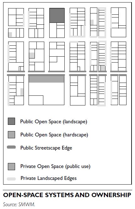
Activity Nodes
The pattern of land uses can help identify major activity centers. While quiet residential neighborhoods are often considered the backbone of the American city, recent interest has focused on major mixed-use activity centers, from the main street to the reinvented mixed-use shopping centers. Patterns and locations of existing activity nodes can be useful to guide locations of future activity nodes, either as expansions of existing nodes or creation of entirely new, and possibly competing, activity nodes.
In addition to zoning maps, plan diagrams can be used to document individual activity generators, and the larger area from which activity nodes draw or could draw population. Annotations on these plans can also indicate publicly versus privately owned activity nodes.
Architectural Character
Analyzing a community’s architectural character can identify significant buildings, provide insight on a community’s values, and help determine the types of buildings residents would like to see in the future. Usually, a few individual buildings are more memorable within a particular community. These buildings often have some historic or architectural significance and are given landmark status, although in some instances they are simply buildings that are important to residents and are considered for protection under local criteria. In addition, a collection of architecturally or historically significant buildings in a neighborhood or district often provides more information about the desired architectural character of a community than a single historic structure.
Axonometric sketches of typical building types and elevation drawings of typical street façades or individual building façades can be used to document a community’s architectural character.
Streetscape
Street character is established by the width of streets, the regular or irregular pattern of buildings facing those streets, the tree planting along those streets and specific design features such as lighting, paving, and street furniture. Mapping more or less consistent characteristics of street design, often along with patterns of open space, is an important component for public realm analysis. Streetscape and public realm standards or guidelines may also be available to guide the type of streetscape elements for future development projects.
Analysis of streetscapes is usually presented through plans and sections of streets and sidewalks, indicating the type and location of amenities.
Environmental Concerns
Document the environmental aspects of a community, which will likely include both natural areas for protection and conservation and built areas where new development may involve cleanup and restoration. Consult recent environmental studies at a local, state, or federal level for issues that are citywide or in the vicinity of a site under analysis. Also be aware that jurisdictions may have adopted environmental protection or cleanup plans. For redevelopment or infill sites, remediation is often required before development can occur. This is particularly relevant in military base redevelopment projects and industrial areas such as former rail yards.
Plan diagrams can be used to document sensitive environmental sites, such as riparian zones or wildlife habitats that need to be protected and sites that require environmental remediation.
Connections
An urban analysis must address all relevant components of an area’s or site’s access characteristics in order to assess the available service to the site, to see how the area is linked to other essential parts of the community, and to understand where a new proposal might serve to fill the gaps or enable access by more alternative modes. A similar analysis is needed to assess the capacity and availability of needed utilities and services.
Included here are checklists of items that should be considered for mapping and capacity, to help identify the opportunities and constraints for the site or area in question.
Street Network and Rights-of-Way
Traffic Parking and Collision Data
Refer to local traffic analysis models for further information on the potential effects of planning or development initiatives.
Transit Modes and Services
Bicycles and Pedestrians
Utilities and Services
ECONOMIC AND MARKET SETTING
An urban analysis may engage economic and market issues in a variety of ways, including the real estate economics that support new development proposals; an assessment of market demand, including unmet needs for residential, retail, office, or other land uses and specific building types; and fiscal analysis, by which a community judges its ability to provide the services needed for a new planned district or site development or public use proposal. Job creation potential may also be important to a community.
Census data can provide a general overview of income levels in a particular community, but it is highly recommended to work with an economist to help ascertain the economic health of a community. This analysis can suggest locations where the community can support additional land uses and services, such as housing or commercial development.
Thorough economic analysis should include identification of all projects or improvements that are currently under construction or that have been given approval to proceed. Any proposed changes to the existing economic base may affect the community’s ability to support future development.
An economic capacity analysis includes a clear understanding of the budget for the project in question. This extends to the sources of funding available for projects, whether they are financed publicly, privately, through public/private partnerships, or through grants, because the available funding often strongly influences the type, scale, and location of development.
CONCLUSION
The findings of research initiatives; a comprehensive review and comparison of these findings to each other; and a comparison of these findings with established community goals, plans, standards, and guidelines conclude a site or area analysis. Maps, diagrams, and spreadsheets should be used to record and display information, summarize findings, and draw conclusions.
In general terms, most urban analyses conclude with a summary of defined constraints and identified opportunities. Findings can be summarized by the physical parameters for construction on-site and off- site, the use program, existing capacities and needed future services, and likely demands on the surrounding area. It may also conclude with identifying gaps in the information that need more study.
The following questions ought to be asked when considering a project:
Consider creating summary maps and diagrams to synthesize the analysis. A comprehensive collection of annotated diagrams that include key findings can help guide choices for the project.
Scale is a qualitative measure of the relative height and massing of buildings and spaces. Density is a quantitative measure of the number of units on a particular area of land, often expressed as the number of people, number of housing units, or amount of square feet of development per land area, typically expressed in acres or square miles.
SCALE
Presented in terms of building height and massing, scale presents distinct planning and urban design issues. Planners and designers are often called upon to address issues of scale in a variety of situations when:
New construction technologies have made it possible to build at much greater scales than those prevalent before the middle twentieth century. These earlier buildings provide the traditional scale familiar to many Americans. Starting in the 1950s, the larger buildings constructed provide a contrast of scale that is both exciting and jarring, uplifting and dehumanizing.

HEIGHT
Attitudes toward height vary from community to community. In Chicago and New York, height is valued; in San Francisco, it is resisted. In Providence, Rhode Island, heights increase closer to the downtown river- front, but in downtown Boston, just 50 miles away, building heights decline toward the waterfront. Such local cultural differences influence decisions about appropriate building heights, as do other objective and subjective considerations, described in the following paragraphs.
Pedestrian Friendliness
Determining how height looks to pedestrians is not an objective measure, yet many zoning codes establish quantifiable limits, such as requiring tall buildings to be set back a prescribed distance at a fixed point above street level, in an effort to make the public realm more hospitable to pedestrians. Several large cities embrace height, and require no setbacks, as long as the public realm meets other standards of pedestrian friendliness.
Height in Relation to Street Width
Building height that is roughly equal to the width of the street the building faces will generally be viewed as reasonable. When height reaches twice the width of the street, many people classify the building as tall.
Framing Public Space
How a building’s height relates to the space it frames shapes perceptions of appropriateness. The concept of a “public room” is often used to envision the positive qualities of a public space that is framed by buildings of similar or compatible heights, or an ensemble of buildings that works with the size, solar orientation, wind conditions, and design potentials of a public park, plaza, or varied civic space.
Symbolism and Identity
A tall building can impart a strong sense of identity, and many communities take pride in their tall structures for this reason. Context and use also play a role, however, calling for use of greater height and distinctive shape and design to signify buildings and uses of importance to a community. In each city or community there is a role for imageable buildings that give identity and for background buildings that establish a context.
Context
In every community, a set of heights—often growing out of tradition—will seem right for a neighborhood, a district, even a city itself. For most of the twentieth century, an informal agreement in Philadelphia limited buildings to 33 stories, a number chosen to maintain the prominence of the statue of William Penn atop City Hall. Today, the two structures that comprise Liberty Place—both higher than City Hall—now define the skyline of Center City Philadelphia. A tower in a neighborhood of three-story houses would strike most observers as out of scale. Within downtown, however, the same building would likely be embraced as a welcome addition to the streetscape and skyline.
Economics
Height can markedly alter project costs, adding to construction cost per square foot as requirements for structural and life safety systems change, for example, but conferring economies of scale on others elements, such as overall land cost per square foot of a new building. In some instances—residential projects in particular—height can contribute significantly to project value. To a lesser degree, height adds value for class A office space but has not been shown to add value to either class B or C office space. (According to the Urban Land Institute’s Office Development Handbook, class A office space is the most desirable in terms of location, design, building systems, amenities, and management, among other features. Class B office space is in good locations and has good management, and was constructed well; it is generally of a generation earlier than class A space. Class C office space is substantially older than A or B and has not been modernized.) Attractive views combined with height, however, almost always add value. Also, height has been found generally not to add value to research-oriented development; in fact, beyond 10 to 12 stories, it begins to add significantly to mechanical costs.
Environmental Considerations
Sun, wind, and shadow concerns assume extra significance when structures reach 12 to 15 stories or more. Designs for buildings at these heights should incorporate measures to mitigate the building’s impact on the public realm. Breaking the building imageable places of civic importance. Some municipalities have written such a prohibition into the zoning code: for example, in Boston, there are strict limitations on new shadows that might be cast on the city’s public garden. For tall buildings, wind tunnel tests should be required, so that pedestrian level effects can be evaluated.
MASSING
Members of the public will often turn to height as a proxy for problems they perceive in scale; but, frequently, it is massing that determines whether a building’s scale feels appropriate. Massing refers to the organization of the building’s overall volume: Is it a slender tower, a low box, or a combination of elements of varying heights, organized to reflect internal functions or external conditions? Many of the same considerations that help define appropriate heights determine whether a building’s massing seems appropriate.
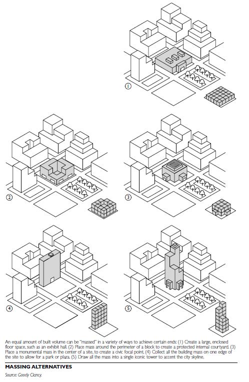
Pedestrian Friendliness
A building’s massing should contribute positively to a pedestrian-friendly public realm. Long, unbroken walls feel overwhelming at street level; the same mass, divided into rhythmic blocks, brings the basic design unit of a façade much closer to human scale. Some cities have written such treatments into their zoning codes or into design guidelines.
Context
Structural massing should respect the surrounding context. In particular, the structure should take design cues from the generally smaller and more articulated massing found in structures built before 1950 to help reduce any perceived context issues regarding size.
Symbolism and Identity
A courthouse or municipal building may warrant a far more monumental design expression than a mixed- use building on an urban main street—even if height and square footage are identical.
Economics
Design variety and façade articulation to address massing concerns can add to project costs; however, some communities require such elements. Various markets require a distinct floorplate, or overall size and configuration of each floor:
DENSITY
Gross density includes infrastructure, such as streets and parks, in the overall density measurement. Net density excludes these features and includes just the area devoted specifically to the structure, including all private land areas and ancillary structures.
Floor area ratio (FAR) is often used to describe density of commercial structures. It is the ratio of built floor area for all floors to the area of the site. A 2 FAR (or 2:1 FAR) allows for 2 square feet of development for every 1 square foot of site area. FAR is also at times expressed as a percentage or a fraction (.50 or 50 percent).
Depending on scale, the same density may look and feel quite different. Perceptions of inappropriate density can trigger strong reactions from the public, with concerns about increased traffic congestion and concentrated poverty. Good design employs scale as a way to make denser development feel humane and look appealing while capturing the benefits it brings to the public realm.
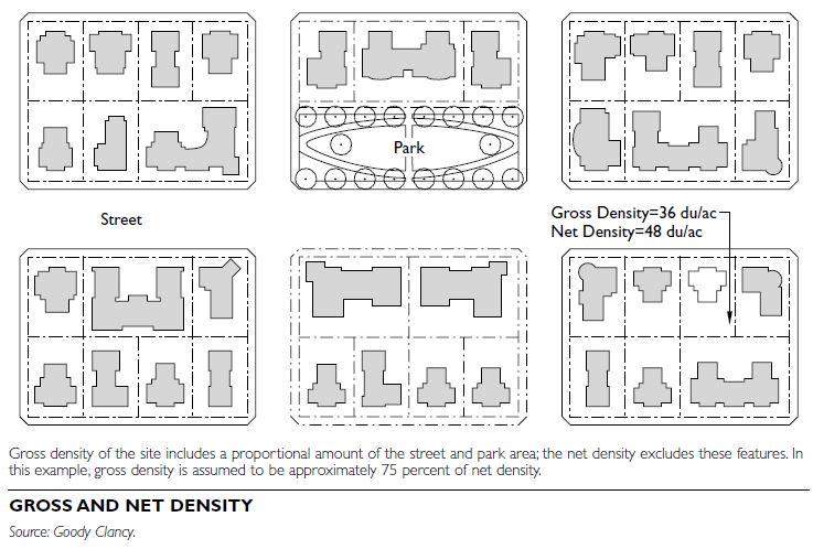
Regional-Level Density Achieving the smart growth ideal of balancing economic development with environmental protection requires directing new jobs, housing, and other growth to developed areas or areas targeted for concentrated development within a region. A 2002 study by the Lincoln Institute for Land Policy projected a $40 billion savings over 25 years if the public sector in the Northeast were to encourage “more compact” development—an essential tactic for maintaining regional economic competitiveness. Density also addresses energy consumption. Denser regions such as the metropolitan areas of New York, San Francisco, and Portland, Oregon, consume far less energy per capita than less-dense regions such as Atlanta and Phoenix.
Community-Level Density
From San Diego, California, to Providence, Rhode Island, cities are encouraging new housing in down- towns and older neighborhood centers to attract “knowledge industry” employees, who often prefer lively, walkable, mixed-use neighborhoods. An accu- mulating body of evidence suggests that higher-density, walkable neighborhoods enhance public health; a recent study that compared a denser city to a less-dense city found that raising density had a more positive impact on health indicators than did increasing income by 50 percent. Compact development also increases transportation options. Walkable neighborhoods that combine housing, schools, jobs, and other uses reduce automobile dependence and broaden the market for public transit.
Neighborhood-Level Density
Density provides the people and disposable incomes required to revitalize older urban neighborhoods. A 2002 study by Goody Clancy suggests that 1,500 to 2,500 new housing units within walking distance are required to sustain a new block of main street retail. As public financial resources shrink, adding density is often critical to paying for parks, street trees, community services, and other “building blocks” of livability. Similarly, increased densities, accompanied by internal subsidies from market-rate units, are one mechanism for providing affordable housing. Increasing densities promotes diversity by supporting a wider range of housing types within a neighborhood.
Comparative Densities
A given density within the same area can take dramatically different forms. Single-family housing developed at 8 to 12 units per acre can resemble a crowded suburb or a classic village neighborhood. A mix of single-family and multifamily housing at 15 to 25 units per acre can resemble an unremarkable apartment complex within a parking lot or Washington, DC’s Dupont Circle neighborhood. At 30 to 50 units per acre—the density of traditional urban neighborhoods—a development can take the form of isolated high-rise apartment buildings or the architectural rhythms of Chicago’s Lincoln Park. Boston Globe architecture critic Robert Campbell has pointed out that Paris is almost four times as dense as Boston, with few complaints.
PLANNING AND DESIGN CONSIDERATIONS
Many communities support a range of densities; it is not uncommon for urban neighborhoods to comprise 100 or more units per acre, with a broad mix of hous- ing types and heights.
Design can help a project capture the benefits of greater density while giving it a scale that feels appropriate. Extend the surrounding neighborhood fabric into the site by employing similar materials, maintaining continuity along the street, designing comparable rooflines and floor-to-floor heights, and making transitions in scale that reflect nearby buildings. A wide range of densities within a mix of land uses should also be considered. A single new housing development can mix rowhouses, lofts, and midrise and high-rise apartments. Older single-use retail centers have been successfully redeveloped with housing on upper floors. Office and research facilities can achieve significantly greater densities if parking is located below grade. Hotels and retail can be successfully integrated with housing and other uses.
When determining the appropriate density of a site, take into account several factors, including the site context, the aspirations and goals of the community, the economics of development, and the building’s or project’s civic role. When scale and density are considered together, they can help developers create public spaces, new buildings, and neighborhoods that respect the past while pointing toward the future.