Prerequisite: Planning 2 or dean's permission
Units: 3.0
Classroom: online via Microsoft Teams
Class Time: Thursday: 9:30 AM-12:30 PM
Office Hour: Thursday: 12:30 PM -12:45 PM - Right after class time
Instructor: Zhuo Yao, Ph.D.
Instructor: Archt. Carmela C. Quizana
Thursday, October 27th, 2022
Instructor:Zhuo Yao Ph.D.
Instructor: Archt. Carmela C. Quizana
Some useful Skills for Students in Architecture/Planning
Fundamentals
Software skills
Ancient Times
Rectilinear plotting with the use of the plow – suited all the needs of agriculture societies on the Nile, Tigris, and the Euphrates river (Fertile Crescent) for easy land division for crop planning, land ownership and land plotting and reapportionment after a flood.
Ancient Greece:
Hippodamus of Miletus (Father of Town Planning) - Greek Architect who emphasized geometric designs grid pattern of streets.
Ancient Rome:
Vitruvius 10-volume treatise “De Architectura” – relates experience of Roman architecture and town design; treats architecture and town design as a single theme; suggested location of streets in relation to prevailing wind; the siting of public buildings; the testing of drinking water; design of plazas
Organization of towns a system of gridiron streets enclosed by a wall; theater, arena and market were common places for public assembly
Perfected enclosed urban and architectural space – colonnaded plazas with a temple or basilica at the end of the space.
Medieval Times
Growth of towns around either a monastery or castle, assumed a radio-centric pattern; relied on protective town walls or fortification for security.
Renaissance Rebirth of classical towns; piazza planning in Venice; grandeur in civic structure and public spaces; streets were wide regular and circumferential with the piazza at the center as in Italy. Pierre Charles L’Enfant - prepared plan for Washington, DC in 1901; axial plan of the Mall; the Reflecting Pool and Lincoln Memorial extend the central axis
Codex Atlanticus
Leonardo da Vinci – in his “Codex Atlanticus” he described a new concept of urban planning that was suited for Milan – sketched a city straddling a river where upstream, the river was directed into 6 or 7 branches, all parallel to the main stream and rejoining it below the city.
Linear City
Arturo Soria Y Mata - Suggested the idea of “Linear City” from Cadiz, Spain across Europe through St. Petersburg, Russia in which he proposed that the logic of linear utility line should be the basis of all city lay-out. Houses and buildings could be set alongside linear utility systems supplying water, communications and electricity. Proposed high-speed, high-intensity transport from an existing city.
The Conservationists and the Park Movement
Frederick Law Olmstead - believed that cities should be planned two generations ahead; maintain sufficient breathing space, be constantly renewed and that suburban design should embrace the whole city; use of open space as element of urban system; despoilment of land through landscape system; urban park as an aid to social reform.
Garden City Movement
Ebenezer Howard - A central city of 58,000 people surrounded by “garden cities” of 30,000 people each separated by permanent green space serving as horizontal fence of farmland; rails and roads would link the towns with industries and nearby towns supplying fresh food. Howard advocated concept of ‘Social City’ – polycentric settlement, growth without limit, surrounded by a greenbelt; town grows by cellular addition into a complex multi-centered agglomeration of towns set against a green background of open country
The 3 magnets in his paradigm depicted both the city and the countryside had an indisoluble mixture of advantages and disadvantages – the city has the opportunities offered through jobs and urban services of all kinds, which resulted in poor natural environment; the countryside offered an excellent natural environment but virtually no opportunities of any kind.
Garden City combined the advantages of the town by way of access and all the advantages of the country by way of the environment without any of the disadvantages of either. Achieved by planned decentralization of workers and their places of employment thus transferring the advantages of urban agglomeration en bloc to the new settlement.
Garden City Association was formed; the first garden city, Letchworth was designed for 35000 persons, it had 16000 population & 100 factories; the 2nd garden city, Welwyn was designed for 40,000 persons, it had 18000 population & 75 factories.
City Beautiful Era
Daniel Burnham - Father of American City Planning; prophet of the City Beautiful Movement. Golden era of urban design in the US; according to Burnham, city was totally designed system of main circulation arteries., a network of parks and clusters or focal buildings or building blocks of civic centers incl. City hall, a country court house, a library, an opera house, a museum, and a plaza.
Total concentration on the monumental and on the superficial, on architecture as symbols of power, and an almost complete lack of interest on the wider social purposes of planning. Planning was intended to impress or for display Castigated by Lewis Mumford as cosmetic, comparing Burnham’s approach with planning practiced in totalitarian regimes; approach ignored housing, schools & sanitation. According to Abercrombie, beauty stood supreme for Burnham, commercial convenience was significant but health and sanitation concerns were almost nowhere. Burnham’s plan devoted scant attention to zoning.
Urban Theorists
Constantine Doxiadis - Published his “Ekistics Grid” a system for recording planning data and ordering the planning process. Approaches town planning as a science which includes planning and design as well as contributions from the sociologist, geographer, economist, demographer, politician, social anthropologist, ecologist, etc. all these he assembles into a total rational and human approach which he calls “Ekistics” – the science of human settlements.
Lewis Mumford - Urged that fundamental needs of the society be the bases for the judicious use of our technological power, a power whose wonders obscure the better ends they might bring. These ends are the harmonious life of civilized social groups in ecological balance with the particular place occupied; recognized the physical limitations of human settlements; wrote “The City in History” (1961)
The New Communities Movement
Clarence Stein - The Radburn Idea or “new town idea” was to create a series of superblocks (an island of greens, bordered by homes and carefully skirted by peripheral auto roads), each around open green spaces which are themselves interconnected. The greenways were the pedestrian ways. The concept of Radburn had the separation of pedestrian and vehicular traffic; Super block - large block surrounded by main roads; houses grouped around small cul-de-sacs - each accessed from main road; Living, Bedroom faced gardens & parks, service areas to access roads; remaining land – park areas; walkways (parklands) – designed such that pedestrians can reach social places without crossing automobile street.
Clarence A. Perry - In a book called “The Neighborhood Unit” (1929) he discussed the idea of organized towns into cohesive neighborhoods which was applicable not only to new towns but to large city areas; developed neighborhood principle in the plans of the 1920s; principle based on the natural catchment area of community facilities such as primary schools and local shops.
The purpose of “The Neighborhood Unit” is to create a safely healthy physical environment in which children will have no traffic streets to cross on their way to school; schools which are within walking distance from home; an environment in which women may have an easy walk to a shopping centre where they may get the daily households goods; employed people may find convenient transportation to and from work; well-equipped playground is located near the house where children may play in safety with their friends for healthy development of their mind and spirit.
The Regional City
Patrick Geddes - “Survey before plan”
The answer to the sordid congestion of the giant city is a vast programme of regional planning within which each sub-regional part would be harmoniously developed on the basis of its own natural resources with total respect for the principles of ecological balance and resource renewal. Cities in the scheme became subordinate to the region; old cities and new towns alike would grow just as necessary parts of the regional scheme. Planning must start with a survey of the resources of such a region and of human responses to it, and of the resulting complexities of the cultural landscape; emphasis on survey method.
Wrote “Cities in Evolution” (1915); coined the term “conurbation” which meant conglomeration of town aggregates; describing the waves of population to large cities followed by overcrowding and slum formation, and the wave of backflow; the whole process resulting in amorphic sprawl, waste and unnecessary obsolescence; stressed social basis of the city – concerned with the relationship between people and cities and how they affect one another.
Stages in the creation of conurbation: Inflow --˃ build-up --˃ backflow(central slums) --˃ sprawling mass (central blight)
Radiant City
Charles-Eduoard Jeanneret - Popularly known as Le Corbusier.
In 1933, proposed “La Ville Radieuse (Radiant City)” anchored on objective to decongest the centres of our cities by increasing their densities by building high on small part of the total ground area. Accordingly, every great city must rebuild on centers. Planned the new capital city of Chandigarh in Punjab, India; criticized for shifting from a planning style to an architectural style, meaning a shift towards the preoccupation with visual form, symbolism, imagery, and aesthetics rather than the problems of the Indian population; plan was completely impervious to economic and human considerations.
Last of the City Beautiful planners, he commented that it was hard to build a City Beautiful amidst the confusion of democracy and the market. Modern Architecture and Planning
Tony Garnier – French architect, anticipated modern day zoning thru “Une Cite Industrielle” (1901-04). The plan is incredibly detailed -- imaginary site (high plateau and level valley along a river); residential on plateaufactories on valley; dam for hydroelectric power; hospital on high hill; smelting factories and mines at respectful distances; locations for sewage plant, abattoir, bakery, and civic center; testing grounds for cars and even airplanes!
Lucio Costa - Planned the new capital Brasilia, the biggest planning exercise of the 20th century; his plans or schemes did not include a single population projection, economic analyses, land use schedule, model or mechanical drawing, yet it was awarded to him; plan did not attempt to resolve pedestrian-vehicle conflicts. Unplanned city grew up beside the planned one. Frank Lloyd Wright - In the 1930s, he wrote the book “The Disappearing City” and later “Broadacres” – proposing that every family live on an acre of land and where the city would be built by its inhabitants using mass-produced components; this met difficulties in land supply and logistics as the population increased.
**Pre-colonial era: **
Barangay is the basic socio-political unit; decentralized; located along coast lines and riverbanks; agricultural and fishing villages.
Spanish era: Manila became capital
1573 – Laws of the Indies pronounced by King Philipp II – Spanish town planning influenced by the Romans and the Piazza planning of Italian Renaissance
1596 – spatial segregation along racial and social lines – Indios and Chinese have separate districts; Parian or market – spatial concentration of merchants and artisans to regulate the exchange of goods
1600s to 1700s – process of Hispanization through the founding of cabeceras (poblaciones) and visitas (barrios); natives living on the unplanned fringes of the neighborhood; debajo de las campanas
early 1600s – Manila became the first primate city in Southeast Asia.
1650 – chapels or small churches in the cabecera were built to attract tenacious natives from the barrios (hinterlands) through fiestas and processions
1790s – opening of the Manila- Acapulco galleon trade; emergence of semi-urban places in the provinces
1850s-late 1800s – Chinese dominated central commercial business districts in all settlements; commercial shops on the ground floor of centrally located houses; no more spatially segregated peripheral clusters of Chinese.; decentralized residential pattern for Spaniards.
American era:
1890s – other port cities continue to become regional urban centers; bridges were built along postal routes facilitating transport in Luzon.
1903 – City of Manila was incorporated covering Intramuros and 12 fast-growing suburban towns.
1905 – Manila and Baguio Plans of Daniel Burnham introduced the City Beautiful western type of town planning.
1910 – rebuilding of settlements, complete with hygiene and sanitary facilities and drainage systems called sanitary barrios.
1920s - Barrio Obrero or the working-class district evolved as government response to the needs of low-income labor families in urban areas.
1928 – zoning ordinance for Manila promulgated but took effect only in 1940; zoning became popular in America in the 1920s.
Post-colonial era:
After the war - RA 333 designated Quezon city as new Capital and master planning it by the Capital city Planning Commission.
1950s - National Planning Commission (later on as NEDA) was established.
RA 2264 – local Autonomy Act of 1959 empowered LGUs to enact zoning ordinances and subdivision rules; all towns and cities required to form planning boards to craft development plans under the guidance of the NPC.
1987 Constitution and Local Government Code of 1991 – devolved powers to LGUs; local autonomy; developments plans under the supervision of NEDA.
Additional Reading:
1) Urban planning: theory and practice / edited by Aysel Uslu, Nasim Shakouri and others. Publisher: New York : Intelliz Press, ©2016 2) https://beat-architect.blogspot.com/2011/03/urban-planning-in-philippines.html 3) http://www-personal.umich.edu/~sdcamp/timeline.html Video References: 1) https://www.youtube.com/watch?v=3lhhLY5Flug 2) https://www.youtube.com/watch?v=Say7pKaPeS8
Planning and Urban Design Standards by Frederick R. Steiner, Kent Butler and Emina Sendich
Edited from the main volume to meet the serious student's needs, this Student Edition is packed with more than 1,400 informative illustrations and includes the latest rules of thumb for designing and evaluating any land-use scheme--from street plantings to new subdivisions. Students find real help understanding all the practical information on the physical aspects of planning and urban design they are required to know, including: * Plans and plan making * Environmental planning and management * Building types * Transportation * Utilities * Parks and open space, farming, and forestry * Places and districts * Design considerations * Projections and demand analysis * Impact assessment * Mapping * Legal foundations * Growth management preservation, conservation, and reuse * Economic and real estate development
Urban Land Use Planning by Philip Berke, Edward Kaiser, David Godschalk and Daniel Rodriguez
Divided into three sections, this edition of Urban Land Use Planning deftly balances an authoritative, up-to-date discussion of current practices with a vision of what land use planning should become. It explores the societal context of land use planning and proposes a model for understanding and reconciling the divergent priorities among competing stakeholders; it explains how to build planning support systems to assess future conditions, evaluate policy choices, create visions, and compare scenarios; and it sets forth a methodology for creating plans that will influence future land use change.
Contemporary Urban Planning by John M Levy
Planning is a highly political activity. It is immersed in politics and inseparable from the law. Urban and regional planning decisions often involve large sums of money, both public and private, with the potential to deliver large benefits to some and losses to others. Contemporary Urban Planning, 11e provides students with an unvarnished and in-depth introduction to the historic, economic, political, legal, ideological, and environmental factors affecting urban planning today, and emphasizes the importance of considering who wins and who loses in planning decision making
City Reader by Richard T. LeGates and Frederic Stout
The City Reader juxtaposes the very best classic and contemporary writings on the city to provide the comprehensive mapping of the terrain of Urban Studies and Planning old and new. The City Reader is the anchor volume in the Routledge Urban Reader Series and is now integrated with all ten other titles in the series. This edition has been extensively updated and expanded to reflect the latest thinking in each of the disciplinary areas included and in topical areas such as compact cities, urban history, place making, sustainable urban development, globalization, cities and climate change, the world city network, the impact of technology on cities, resilient cities, cities in Africa and the Middle East, and urban theory. The new edition places greater emphasis on cities in the developing world, globalization and the global city system of the future.
The Death and Life of Great American Cities by Jane Jacobs (1961) A classic since its publication in 1961, this book is the defintive statement on American cities: what makes them safe, how they function, and why all too many official attempts at saving them have failed. The New York Times writes: "Perhaps the most influential single work in the history of town planning."
The City in History: Its Origins, Its Transformations, and Its Prospects by Lewis Mumford (1972) A history of the forms and functions of the city throughout the ages, and a prophecy for the future of cities and urban life. The City in History was awarded the National Book Award in 1962.
Local Planning: Contemporary Principles and Practice Edited by Gary Hack, et al. (2009) The eight chapters in Local Planning, roughly spanning from context to applications, consists of articles written by a wide range of experts-academics, practitioners, clients, and observers of planning.
Civilizing American Cities: Writings on City Landscapes by Frederick Law Olmsted (1997) Civilizing American Cities collects Olmsted's plans for New York, San Francisco, Buffalo, Montreal, Chicago, and Boston; his suburban plans for Berkeley, California and Riverside, Illinois; and a generous helping of his writings on urban landscape in general. These selections, expertly edited and introduced, are not only enjoyable but essential reading for anyone interested in the history--and the future--of America's cities.
The Image of the City by Kevin Lynch (1960)
What does the city's form actually mean to the people who live there? What can the city planner do to make the city's image more vivid and memorable to the city dweller? To answer these questions, Mr. Lynch, supported by studies of Los Angeles, Boston, and Jersey City, formulates a new criterion -- imageability -- and shows its potential value as a guide for the building and rebuilding of cities.
The American City: What Works and What Doesn't by Alexander Garvin (1995) This definitive sourcebook on urban planning points out what has and hasn't worked in the ongoing attempt to solve the continuing problems of American cities. Hundreds of examples and case studies clearly illustrate successes and failures in urban planning and regeneration, including examples of the often misunderstood and maligned "Comprehensive Plan."
Good City Form by Kevin Lynch (1995)
Lynch looks at connections between human values and the physical forms of cities, sets requirements for a normative theory of city form, reviews earlier physical images of what utopian communities might be, sees what is to be learned from hellish images, and helps us place city forms into one or another of three theoretic constructs; cosmic or ceremonial centers, the machine city, and the city as an organism.
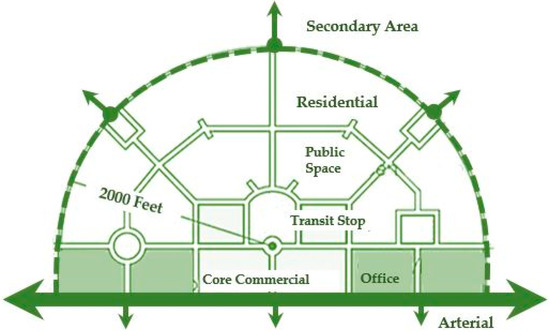
The Next American Metropolis: Ecology, Community, and the American Dream by Peter Calthorpe (1993)
One of the strongest supporters of New Urbanism, architect and urban designer Peter Calthrope makes the case for compact, mixed-use development over the urban sprawl that has dominated much of the development in the past decades. Twenty-four regional plans are presented in the book, focusing on reducing dependance on the automobile and increasing the proximity between home, work, shopping and recreation.
Cities of Tomorrow: An Intellectual History of Urban Planning and Design in the Twentieth Century by Peter Geoffrey Hall (1996 Updated Edition)
Cities of Tomorrow is an overview of the ideas, events, and personalities that have shaped world urbanization since 1900. The book is organized into ten chapters that treat late 19th-century slums; mass-transit suburbs; the garden city movement; the genesis of regional planning; the 'city beautiful' crusade; the skyscraper city; the city of 'sweat equity'; automobile suburbs; the city of theory; and contemporary urban redevelopment.
A Pattern Language: Towns, Buildings, Construction by Christopher Alexander, Sara Ishikawa, and Murray Silverstein (1976)
"Here's how to design or redesign any space you're living or working in -- from metropolis to room. Consider what you want to happen in the space, and then page through this book. Its radically conservative observations will spark, enhance, organize your best ideas, and a wondrous home, workplace, town will result" --San Francisco Chronicle. This handbook is designed for the layperson and aims to present a language which people can use to express themselves in their own communities or homes.
Design With Nature by Ian L. McHarg (1995)
The first book to describe an ecologically sound approach to the planning and design of communities, Design with Nature has done much over the past 25 years to shape public environmental policy. This paperback edition makes this classic accessible to a wider audience than ever before. Lavishly illustrated with more than 300 color photos and line drawings.
Planning in the USA: Policies, Issues, and Processes by Barry Cullingworth, and J. Barry Cullingworth (1997)
This comprehensive introduction to the policies, theory and practice of planning outlines land use, urban planning and environmental protection policies and explains the nature of the planning process.
Hand sketches the following plans (no tracing, scanned or photoshop corrected plan vie):